


Ireland’s Historic Buildings : Pearse’s Cottage (Teach an Phiarsaigh),Rosmuc, County Galway
Patrick Henry Pearse (also known as Pádraig or Pádraic Pearse; Irish: Pádraig Anraí Mac Piarais; An Piarsach) was born in Dublin on the 10th of November 1879 and he died in Kilmainham Gaol(Jail), county Dublin on the 3rd of May 1916. He was primarily an Irish teacher but was also a great barrister, poet, writer and original Irish nationalist. He was one of the leaders of the Easter Rising in 1916. Following his execution along with fifteen others, Pearse came to be seen by many as the embodiment of the rebellion.
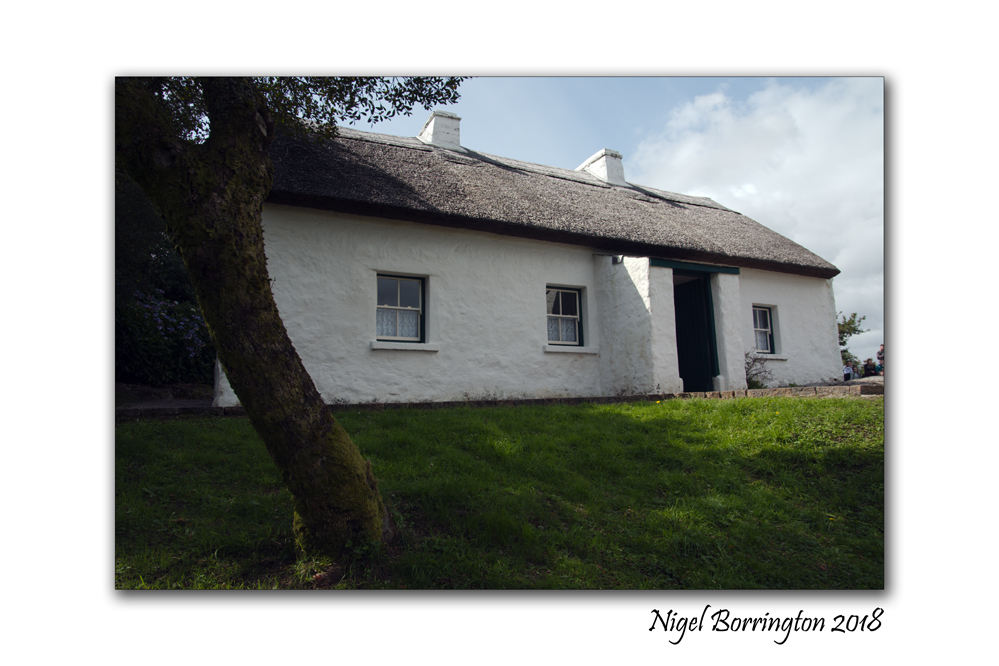
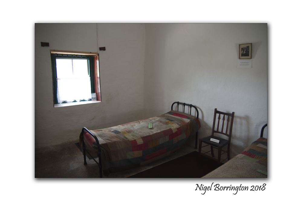
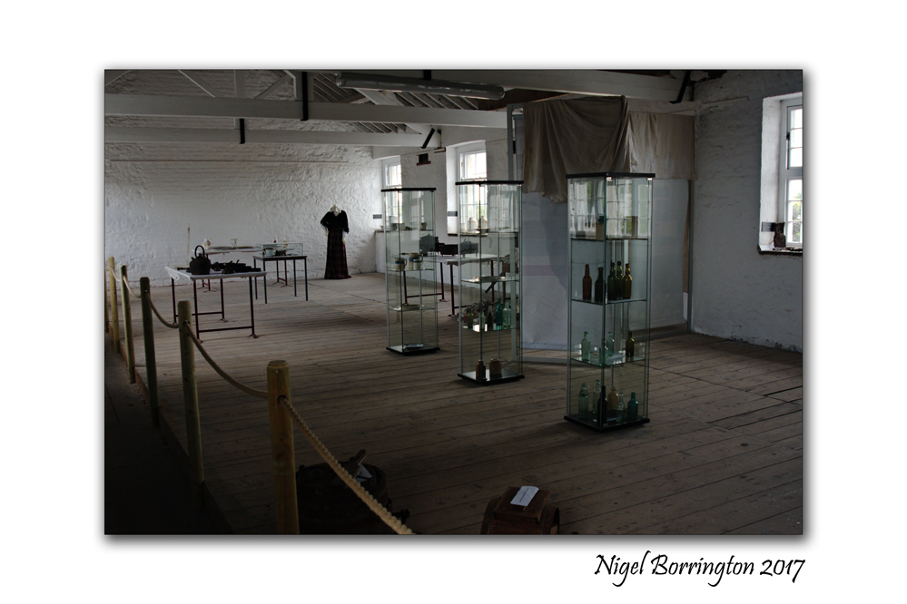
Patrick Pearse’s Cottage at Ros Muc, county Galway in the heart of the Conamara Gaeltacht, ( an Irish speaking and strongly Irish cultural area) was used by Patrick Pearse (1879 – 1916), while he spent time teaching and marking students papers.
The cottage and its interior, although burned during the War of Independence, has been perfectly reconstructed and contains an exhibition and a number of momentous of Pearse’s life.
The cottage was Pearse’s summer residence between 1903 and 1915. It was also as a summer school for his pupils from St Enda’s in Dublin where he worked during the main Academic year.
The historic cottage, has been developed as a national monument and tourist attraction as part of the 1916 centenary commemorations; and is a key ‘discovery point’ on the Wild Atlantic Way route.
I was lucky enough to visit the cottage last week and enjoyed my time here very much, the staff helped greatly when it came to understanding the life of this great Irish man and his time spent here.
If your in county Galway, you just have to call in and spend some valuable time here !
Pearse’s Cottage (Teach an Phiarsaigh), County Galway, Gallery


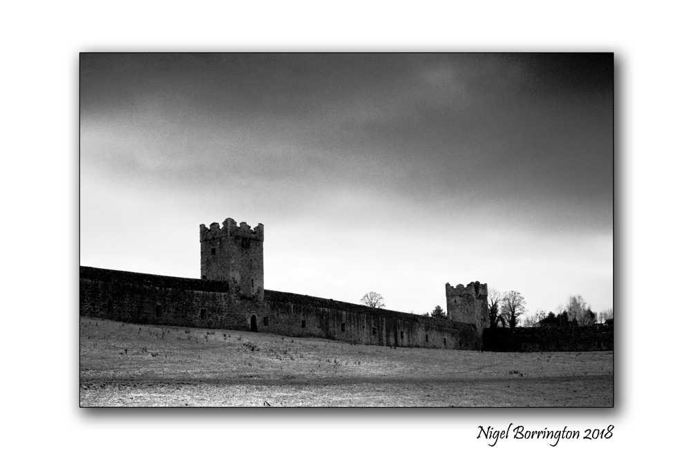
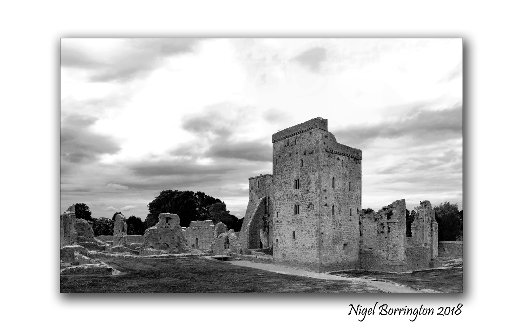
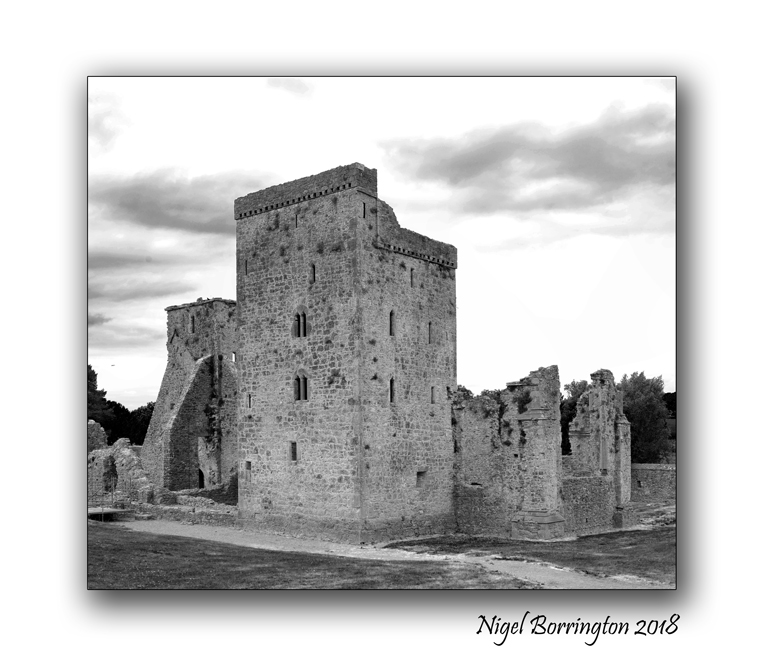
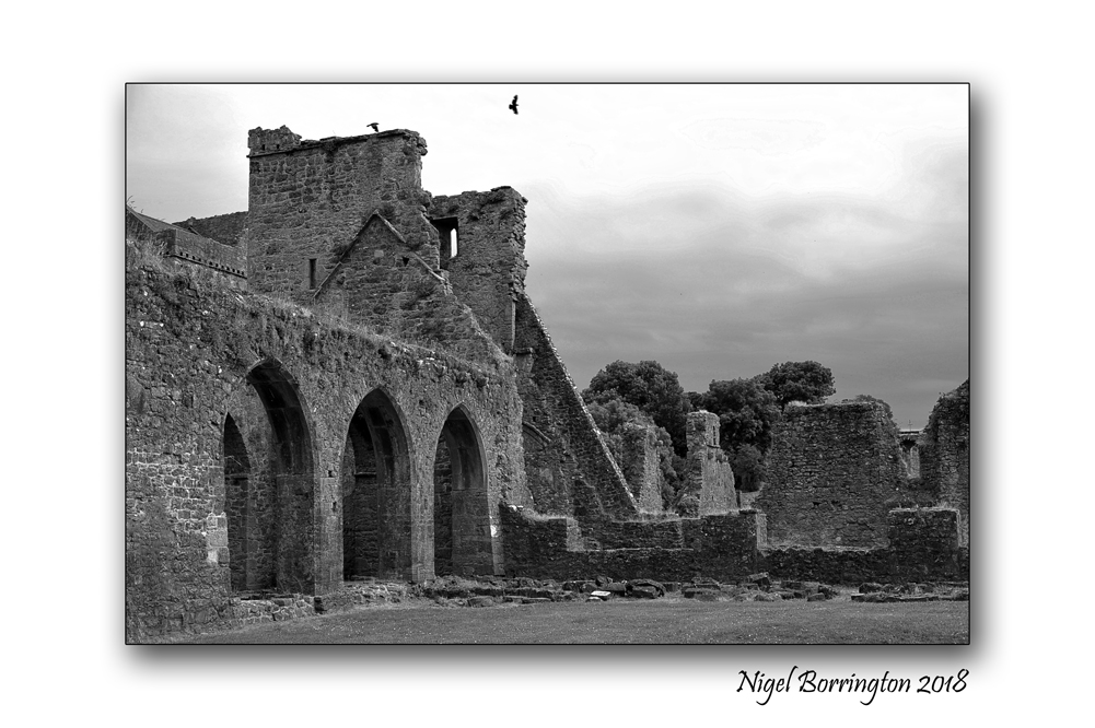
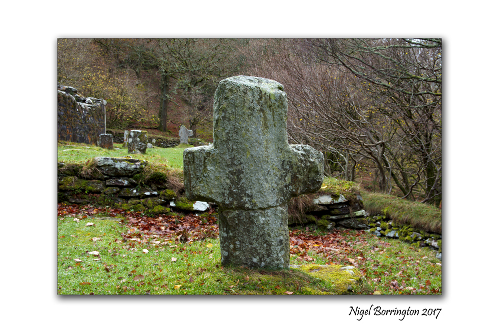
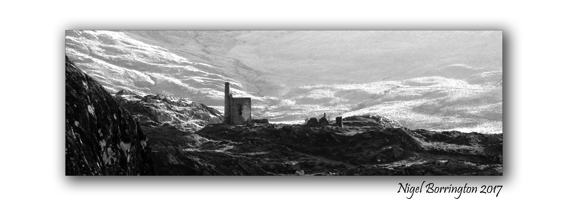
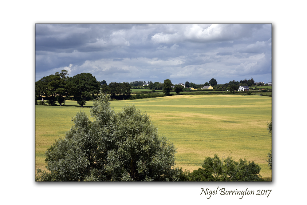
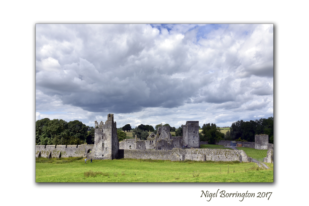
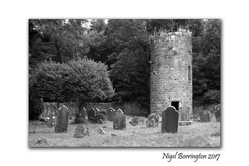
Kilcooley Abbey, County Tipperary. The silence of the Abbey in the field.

Kilcooley abbey is located near the town of Thurles in county Tipperary, it was founded by the Cistercians in 1182AD when the lands were granted to them by Donal Mor O’Brien. It became one of the three great Abbeys in the local area, the other two being Jerpoint and Holy Cross.
It would have been in use at least until the dissolution of Abbeys in the 1500’s and it now sits hidden away on the lands of the Kilcooley estate.
I always love visiting this abbey as its one of the most peaceful of places you could wish of, surrounded by woodlands and farms, very little sound from the modern world penetrates the field its located in. As such you can sense the times when this abbey was first lived in and used on a daily basis as a refuge and place of worship for the Cistercian monks who would have lived here.
If there are such things a Ghosts then how could they not be found still living within and around the grounds of this great Abbey.


Ghost House in the Irish landscape, Poem by Robert Frost, 1874 – 1963
Ghost House
Robert Frost, 1874 – 1963
I dwell in a lonely house I know
That vanished many a summer ago,
And left no trace but the cellar walls,
And a cellar in which the daylight falls
And the purple-stemmed wild raspberries grow.
O’er ruined fences the grape-vines shield
The woods come back to the mowing field;
The orchard tree has grown one copse
Of new wood and old where the woodpecker chops;
The footpath down to the well is healed.
I dwell with a strangely aching heart
In that vanished abode there far apart
On that disused and forgotten road
That has no dust-bath now for the toad.
Night comes; the black bats tumble and dart;

The whippoorwill is coming to shout
And hush and cluck and flutter about:
I hear him begin far enough away
Full many a time to say his say
Before he arrives to say it out.
It is under the small, dim, summer star.
I know not who these mute folk are
Who share the unlit place with me—
Those stones out under the low-limbed tree
Doubtless bear names that the mosses mar.
They are tireless folk, but slow and sad—
Though two, close-keeping, are lass and lad,—
With none among them that ever sings,
And yet, in view of how many things,
As sweet companions as might be had
Cutting Turf , Irish landscape History

Irish Bog lands and Turf cutting
Irish landscapes
Nigel Borrington
On Wednesday I posted some picture showing the results of a Wildfire on the bog lands of Littleton in country Tipperary, having done so I just wanted to share some more images from another Bog land in county Waterford and share some of the history of these amazing places along with some details about the history of turf cutting in Ireland.
The Irish tradition of turf cutting
In the past, Irish people heated their homes and cooked their food using turf taken from from the bog as fuel. Turf was cut from the bog by hand, using a two-sided spade called a sleán. Entire families often helped to save the turf on the bog.
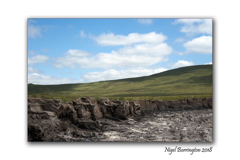
Saving the turf involved turning each sod of turf to ensure the sun and wind could help in the drying process. The turf was then placed upright or ‘footed’ for further drying. Footing the turf was a back-breaking job and involved placing five or six sods of turf upright and leaning against each other. Finally, the turf was brought home and stored in sheds or ricks.

In the midlands and the West of Ireland, the tradition of using turf or peat as fuel has continued in many homes.The turf is mainly cut by machine nowadays, but saving the turf still involves lots of work and requires good weather.


Tuesday Morning on the River, Bagenalstown, River Barrow, county Carlow

Morning on the river
Bagenalstown
county Carlow
Nigel Borrington 2018
Bagenalstown, county Carlow
One of my most loved small towns located along the river Barrow as it flows through county Carlow is Bagenalstown, it is located of the side of the hills that surround the river barrow south of Carlow town. Otherwise known in its Gaelic version as Muine Bheag it is a pleasant stretch of the River Barrow and derives its name from Walter Bagenal, who, in founding the town, had visions of mirroring the city of Versailles, in northern France.
However, his efforts became frustrated due to the re-routing of the coach road away from the town. He left more than enough for visitors to enjoy with handsome stone public buildings including the impressive Courthouse, now a public library in Bagenalstown.

The arrival of the railway in 1846 rejuvenated the town, and its neo-classical railway station is one of the finest in Ireland. Attributed to William Deane Butler it is constructed of limestone and granite and is a seven bay, two-storey building in an Italianate villa style. Today Bagenalstown station still retains its charm in a largely unaltered state. This former mill town made full use of the river Barrow to transport grain, beet, coal, turf and Guinness by barge, evidence of which can be seen in its fine industrial architecture. Near the railway bridge on the R705 Borris road is an example of the Carlow fence which consists of a decorative fence made of granite pieces, laid horizontally over vertical posts and is found nowhere else in the world.
One of the finest views of Bagenalstown may be enjoyed on the approach road from Leighlinbridge and includes the spire of St. Andrew’s Catholic Church and the fine tower of St. Mary’s Church of Ireland Church. St. Andrew’s Catholic Church was built in 1820 on a site provided by the Newton family, successors to the Bagenals. The stained glass behind the altar is worthy of particular attention. Nowadays, riverside walks, picnic tables and a picturesque lock enhance this fine town which has been twinned with the French town of Pont Pean since 1999.

ATTRACTIONS: The ruins of the early 14th century Ballymoon Castle and 13th century Ballyloughan Castle are located near the town. Wells Church, situated closeby, is the preserved ruin of a church dating back to 1262. The church is surrounded by an enclosed and well-maintained graveyard which is still in use today.
ACTIVITIES: Outdoor swimming pool. The McGrath complex offers excellent sporting facilities including cricket, hurling, soccer and Gaelic football fields, tennis court and pitch and putt courses. The River Barrow in this area is renowned for coarse fishing with wheelchair friendly fishing stands located near the swimming pool. The Barrow Way long distance walking route passes through the town.
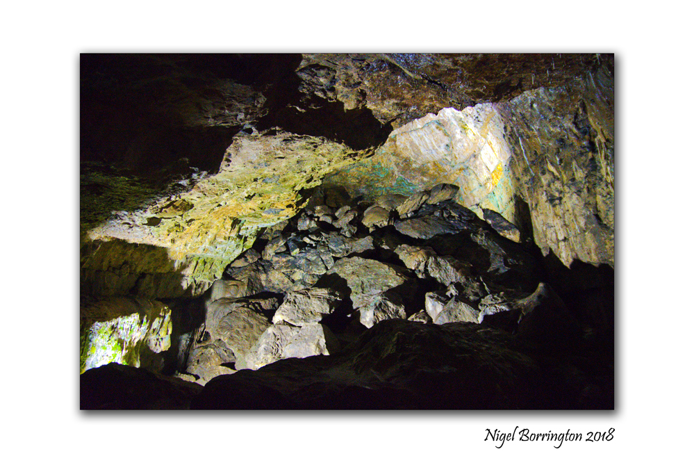
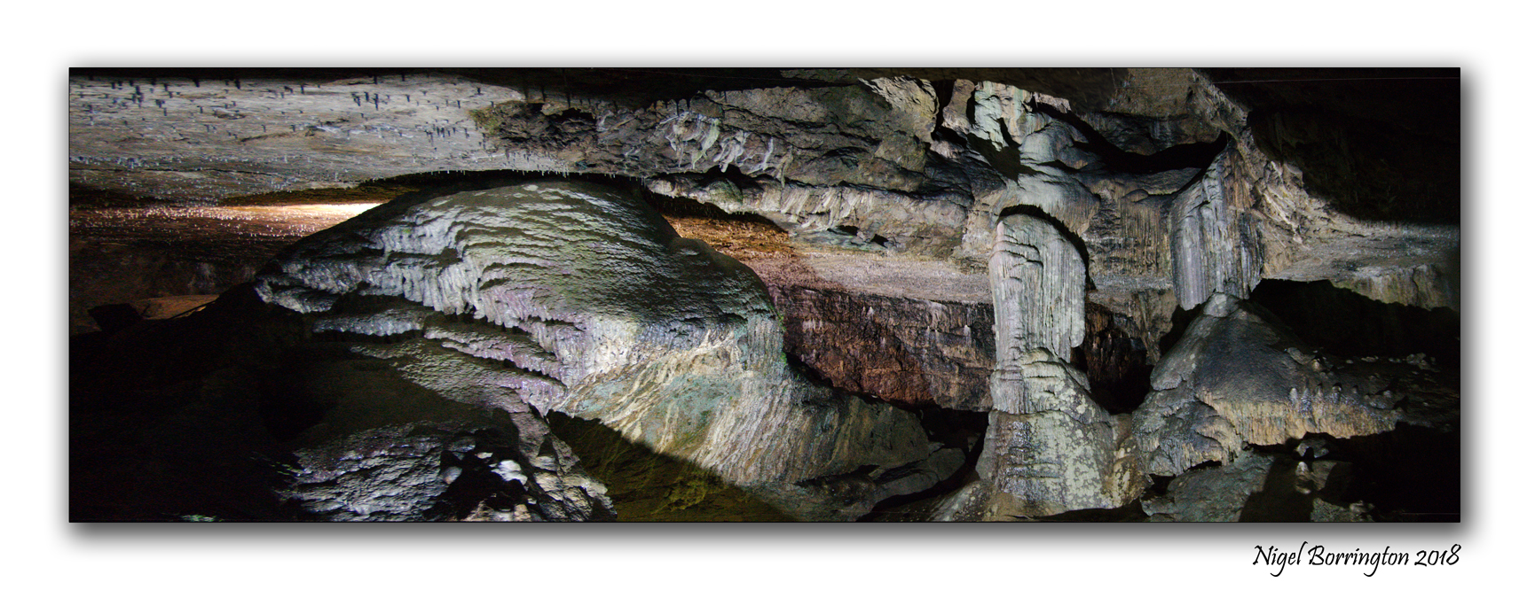
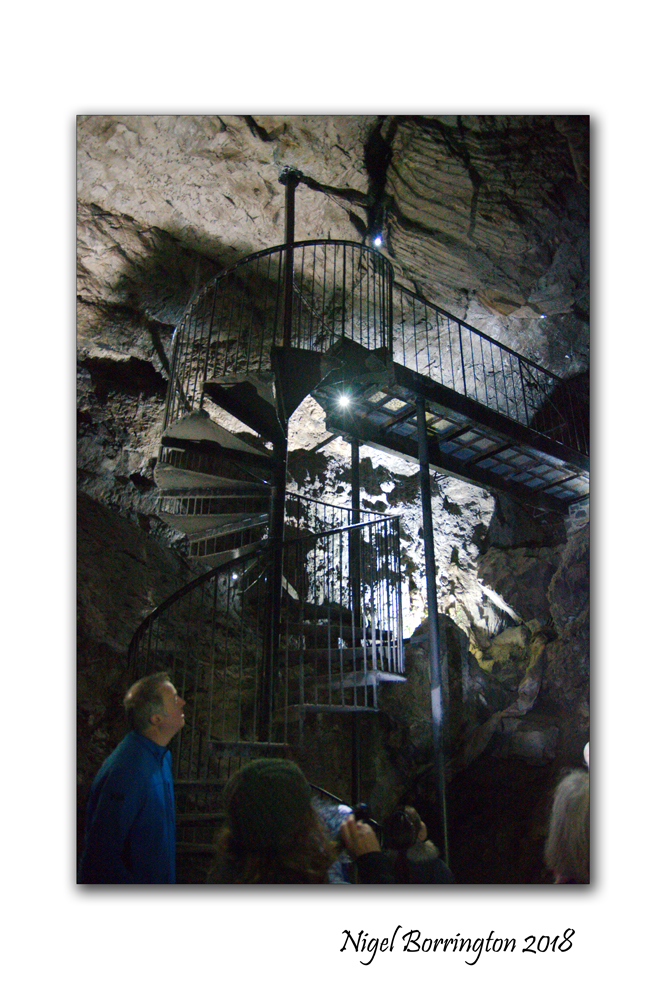
Visiting the Underworld, Dunmore caves, county Kilkenny Ireland
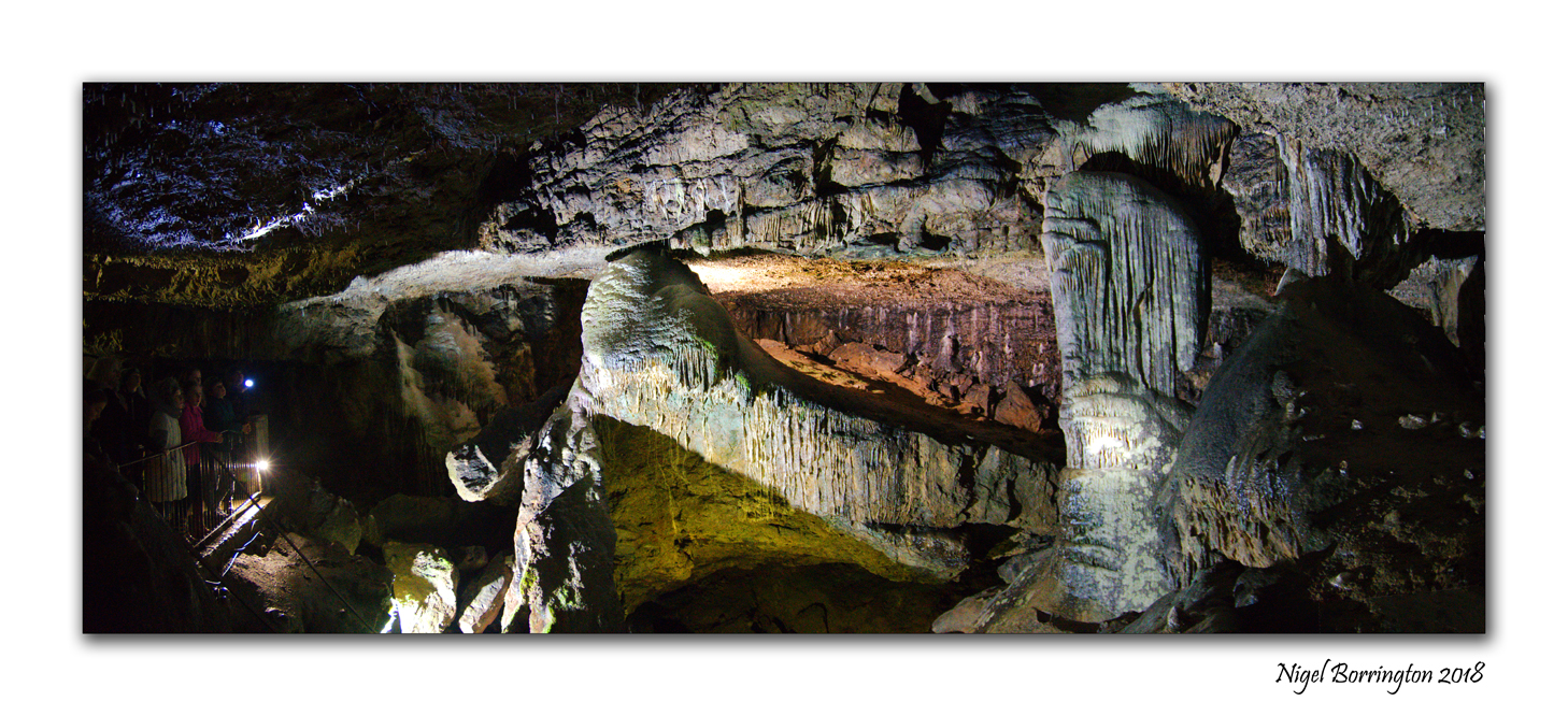
Dunmore caves
County Kilkenny
Nigel Borrington 2018
The Easter holidays are always a great time to do some different activities and visited some locations I had on my list for sometime.
One of these locations was Dunmore caves in the north of county Kilkenny, the caves are some of the most spectacular – located here in Ireland, with a large entrance hall and a great mix of tunnels and caverns. This time was a great visit, there have been some great guides over the years but our female guide over the weekend was clearly into the geology and environment of the area and of the caves themselves along with the Pagan and Viking (history, myths and beliefs) based around the long time use of these caverns.
One local myth in Kilkenny county revolves around the belief that there is a tunnel that goes all the way from the caves into the center of kilkenny city, possibly used for escape in times when the city was under attack. This tunnel has been searched for many times but never found, so maybe it is just a story but the search goes on.
Dunmore caves facts and History
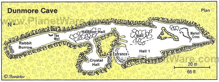
Dunmore Cave (from Irish Dún Mór, meaning ‘great fort’) is a limestone solutional cave in Ballyfoyle, County Kilkenny, Ireland. It is formed in Lower Carboniferous (Viséan) limestone of the Clogrenan Formation. It is a show cave open to the public, particularly well known for its rich archaeological discoveries and for being the site of a Viking massacre in 928.
Development
Dunmore Cave was designated a National Monument by the Commissioners of Public Works in 1944, but development as a show cave with visitor centre and tours didn’t begin until 1967, at the behest of respected archaeologist and spelaeologist J. C. Coleman. The cave was closed in 2000 for archaeological work and redevelopment, and reopened in 2003.
History
The earliest historical reference to the cave is to be found in the Triads of Ireland, dating from the 14th to the 19th century, where “Úam Chnogba, Úam Slángae and Dearc Fearna” are listed under the heading, “the three darkest places in Ireland”.The last, meaning the “Cave of the Alders,” is generally thought to be the present Dunmore Cave, while the first two translate as the caves of Knowth and Slaney. It is not known which exact system of caves/passage tombs near the river Slaney is being referred to, with the most likely, those at Baltinglass. Other sources translate the listed locations as Rath Croghan, the cave or crypt of Slane and the “Cave of the Ferns”.
In the Annals of the Four Masters, dated to the 17th century, Dearc Fearna was recorded as the site of a great Viking massacre in 928 AD:
“Godfrey Uí Ímair, with the foreigners of Ath Cliath, demolished and plundered Dearc Fearna, where one thousand persons were killed in this year as is stated in the quatrain:
Nine hundred years without sorrow, twenty-eight, it has been proved, ‘Since Christ came to our relief, to the plundering of Dearc-Fearna.”
Gofraith, ua h-Iomhair, co n-Gallaibh Atha Cliath, do thoghail & do orgain Derce Fearna,
airm in ro marbhadh míle do dhaoinibh an bhliadhain-si, amhail as-berar isin rann,
Naoi c-céd bliadhain gan doghra,
a h-ocht fichet non-dearbha,
o do-luidh Criost dár c-cobhair
co toghail Derce Ferna.
While the human remains found in the cave are thought to be victims of the Viking massacre, this has not been reliably confirmed. Many of the remains belong to women and children, and it is hypothesised that they are the bodies of people hiding in the cave who were unable to leave when the Vikings tried to smoke them out, dying from asphyxiation.
Archaeological study
The earliest writings on the cave of an archaeological nature came from the bishop George Berkeley, whose report dated 1706 detailed a visit that he made to the cave as a boy. The essay was not published until 1871. In 1869 Arthur Wynne Foot, a physician, made an archaeological visit to the cave with Rev. James Graves and Peter Burtchaell and discovered large quantities of human remains, which they collected. In his reports, Foot meticulously documented his findings, and culled references from the writings of researchers over the preceding 120 years.
In 1999, a hoard of 43 silver and bronze items was discovered in a rocky cleft deep in the cave. Archaeologists dated this hoard, consisting of silver, ingots and conical buttons woven from fine silver, to 970 AD.

Dunmore caves
Visitors center
Count Kilkenny
Ireland
Nigel Borrington 2018


Irish Landscape Images : The Hell Fire Club, Mount Pelier Hill

The Hell Fire Club
Mount Pelier Hill
County Dublin, Ireland
Irish Landscape Images
Nigel Borrington 2018
The Hell Fire Club on Mount Pelier Hill
William Conolly’s Hunting Lodge
The building now known as the Hell Fire Club was built around 1725 as a hunting lodge by William Conolly, the Speaker of the Irish House of Commons. It was named Mount Pelier by Conolly but over the years has also been known as “The Haunted House”, “The Shooting Lodge”, “The Kennel”, and “Conolly’s Folly”. It was one of several exclusive establishments using the name Hellfire Club that existed in Britain and Ireland in the 18th century.
While the building has a rough appearance today, the architecture is of a Palladian design. The upper floor consists of a hall and two reception rooms. On the eastern side, there was a third, timber-floored, level where the sleeping quarters were located. On the ground floor is a kitchen, servants’ quarters and stairs to the upper floors. The entrance, which is on the upper floor, was reached by a long flight of stairs which is now missing. At each side of the building is a room with a lean-to roof which may have been used to stable horses. A stone mounting block to assist people onto their horses can be seen on the eastern side. To the front there was a semi-circular courtyard, enclosed by a low stone wall and entered by a gate.

View of Dublin port
From Mount Pelier Hill
Irish Landscape Images
Nigel Borrington 2018
The house faces to the north, looking over Dublin and the plains of Meath and Kildare, including Conolly’s primary residence at Castletown House in Celbridge. The grounds around the lodge consisted of a 1,000-acre (4.0 km2; 1.6 sq mi) deer park. The identity of the architect is unknown: the author Michael Fewer has suggested it may have been Edward Lovett Pearce (1699–1733) who was employed by Conolly to carry out works at Castletown in 1724.
There was a prehistoric burial site at the summit of Mount Pelier Hill and stones from it were used in the construction of the lodge. A nearby standing stone was also used for the lintel over the fireplace. Shortly after its completion, a great storm blew the original slate roof off. Local superstition held that this was the work of the Devil, an act of revenge for disturbing the ancient cairn. Conolly had the roof replaced with an arched stone roof constructed in a similar fashion to that of a bridge. This roof has remained intact to the present day, even though the building has been abandoned for over two centuries and despite the roof being set alight with tar barrels during the visit of Queen Victoria to Ireland in 1849. There is little evidence that the lodge was put to much use. Conolly himself died in 1729.
Irish Archaeology, Brownshill Portal Tomb, Co. Carlow

Brownshill Portal Tomb, Co. Carlow
Irish Archaeology
Nigel Borrington
Dating from the Early Neolithic period (4000-3000 BC), Brownshill dolmen in Co. Carlow is one of the most impressive megalithic monuments in Ireland. The capstone is truly massive and has to be seen in person to be really appreciated. It is estimated to weigh in excess of 150 tonnes and is believed to be one of the heaviest capstones in Europe. It is still not certain how it was raised up, but it may have involved a combination of wooden rollers, ropes and man/animal power, aided by ramps of earth or stone.
The Brownshill dolmen is classified as a portal tomb by archaeologists and there are approximately 174 of these monuments in the country. The tombs generally consist of two large portal-stones defining the entrance and a back-stone, all of which support the cap-stone. Although Brownshill has never been excavated, finds are known from other portal tombs. These include burnt and unburnt human bone, pottery and flint artefacts as well as personal items such as bone pins and beads.
One of the very few portal tombs that has been investigated by archaeologists is Poulnabrone in Co. Clare (Lynch 2014). At this site the remains of twenty two people were uncovered inside the tomb, including sixteen adults and six children. Of these bodies only eight could be sexed and these were equally split between males and females. The bones were found in a largely disarticulated state and this suggests that the human remains had undergone a complex burial ritual. It appears that the dead were initially placed in the tomb as complete bodies and allowed to decompose. Then at a later date certain body parts were removed, in particular the skulls and long bones. The reasoning behind this is uncertain, although it may have been related to some form of ancestor worship, where the dead, via their skeletal remains, continued to play a role in the daily lives of their descendants.
A truly ancient monument, Brownshill portal tomb is located just outside the town of Carlow and is easily accessible, with a small car park present and path leading up to the monument. If you are ever in the area you should definitely visit!
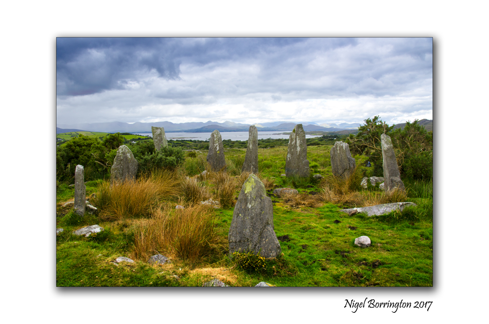
The week of the winter solstice – Ardgroom Stone Circle, County Cork, Ireland
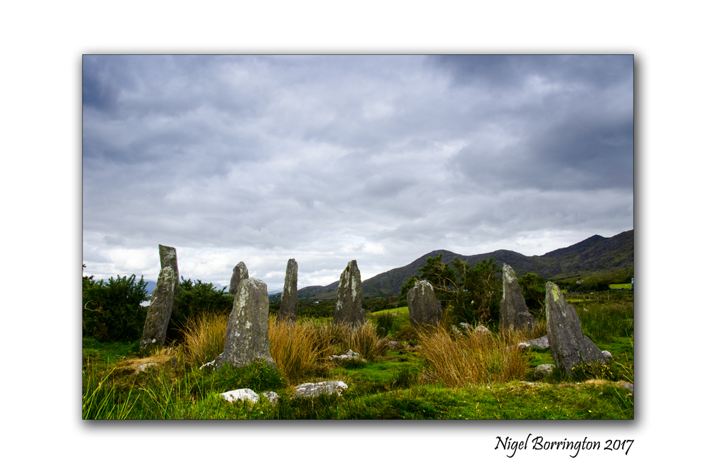
Ardgroom Stone Circle, County Cork,
Ireland
Nigel Borrington
Ardgroom Stone Circle, County Cork, Ireland
The Ardgroomon stone circle is located on the Beautiful Beara Peninsula, county cork. It has to be one of the most magical of all the Irish stone circle, it also has the best of locations and views, sitting about the Atlantic ocean. There is something so exciting and mysterious about visiting a stone circle. The Ardgroomon circle is located in an area were there is an abundance of these historic sites, as well as wedge tombs, ring forts, boulder burials and fulachta fiadhs.
As well as being used for the Solar Spring and summer Equinox’s along with the Summer and Winter Solstice, many of these stone circles would also log the Movement of the Moon, Planets and Stars as during the year they changed their positions along the horizon. The standing stones in a stone circle would have in combination with a feature on local hill sides, have been lined up with astronomical objects(Sun, moon, planets and Stars). This would have given an almost daily measurement for months of the year.
The reason that ancient peoples needed to log the movement of the heavens was mainly for practical reasons such as farming, they needed to know when to sow seeds, bring cattle down from the mountains and bring in the crops, also they needed to know how long their store of food had to last before the new growing season started, no imports in those days.


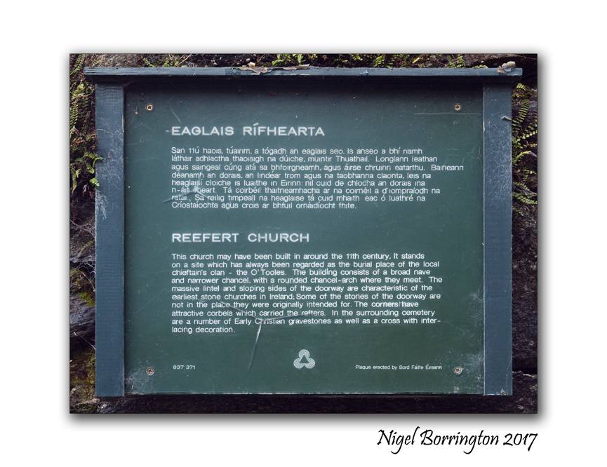
Reefert church, Glendalough, County Wicklow

Reefort, Glendalough Monastic City, Glendalough
Glendalough has one of the biggest collections of Monastic remains in Europe, one of the most beautiful simply has to be Reefort church, located in the ancient woodlands above the lough this little chapel and is small grave yard are such a perfect reminder of an age that has long past us by.
The remains of Reefert Church are situated in a oak woodland setting, on the south-eastern shore of the Upper Lake close to an Information Office. Reefert derives its name from the Irish ‘Righ Fearta’ meaning burial place of the kings (referring to the local rulers – the O’Toole family). It dates from the eleventh century and is likely to have been built on the site of an earlier church. The church and graveyard were originally surrounded by a stone wall enclosure known in Gaelic as a ‘caiseal’. Most of the present surrounding walls however are modern. The upper parts of the church walls were re-built over 100 years ago using the original stones.
Gallery


One hour sketch (Pencil on paper), Killamery church yard, county KIlkenny
One hour sketch Killamery church yard county kilkenny
Nigel Borrrington
The old church yard at Killamery county Kilkenny is most famous for its highcross pictured here at the bottom of the post. The old church and grave yard however are just as interesting, the history of the area includes it being the location of a very large monastic site covering what would have been many large building now completely lost in time.
My sketch here I hope helps capture a sense of this wonderful place located on the boarder between county kilkenny and county Tipperary.

Killamery High cross Nov 2014
Kilkenny landscape Photography : Nigel Borrington
Kells priory, county Kilkenny, Art work and Photography.

Kells Priory
County Kilkenny
Pencil on Paper
Nigel Borrington
One of the location that I love to take both my camera and sketch book is Kells Priory, county Kilkenny. Its an amazing location to capture in many forms and I am very lucky to live only a few miles away. I have posted here on my blog about it many time, you can used the search box to find these post if you wish.
The above is a Pencil on Paper drawing I worked on from about two weeks ago and below is a photo taken earlier in the summer when there was many more visitors around the site.

Ancient Ireland : Poulnabrone Dolmen and Portal Tomb, Caherconnell, county Clare Ireland
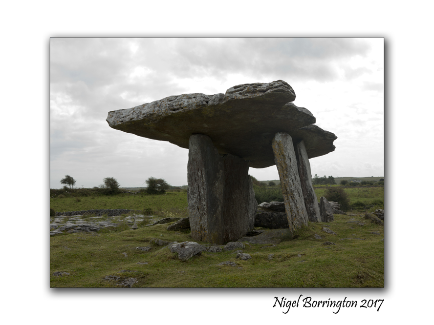
Poulnabrone Portal tomb
County Clare
Ireland
Nigel Borrington
Poulnabrone Dolmen and Portal Tomb is one of the most Dramatic megalithic sites in Ireland, it has superb sculptured form and is easily access from the road.
During the summer months it must be one of the most visited dolmens in the country. The day I visited and took these pictures it was overcast and grey, so there was less visitors than I can imagine at other times. When the site was excavated in 1986 they found some human remains some 16 adults and children plus some of their artifacts, together they dated the tomb to around 3600 B C.
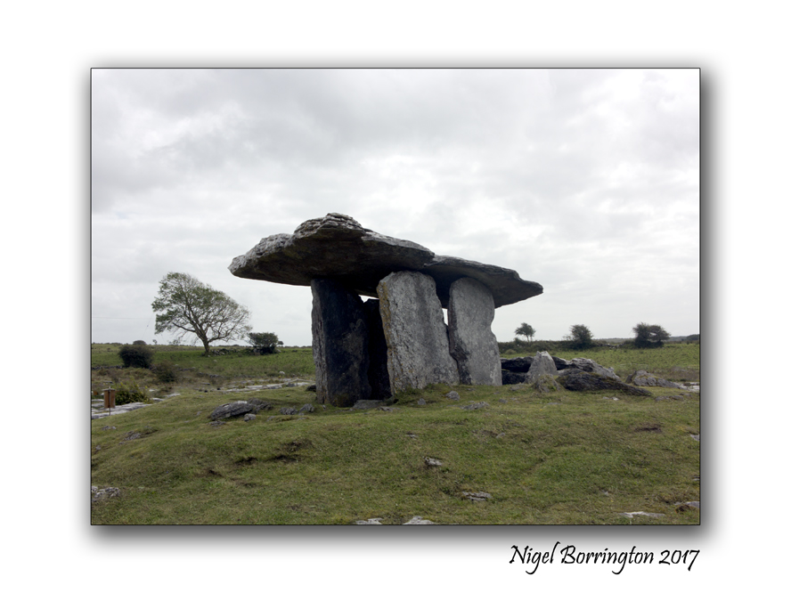
The entrance some 2 meters high faces north, The capstone is tilted at the usual angle for a Doland of this type, it measures about 3 1/2 metres long and some 2 metres wide.
The name Poulnabrone means ‘ the hole of the sorrows’ There are many other interesting sites near poulnabrone including the Wedge tomb at Gleninsheen and Baur South and the Stone Fort at Caherconnell.

Situated on Karst limestone, in a field east of the Ballyvaughan – Corrofin Road the Poulnabrone Dolmen is one of Irelands more accessable megalithic structures.
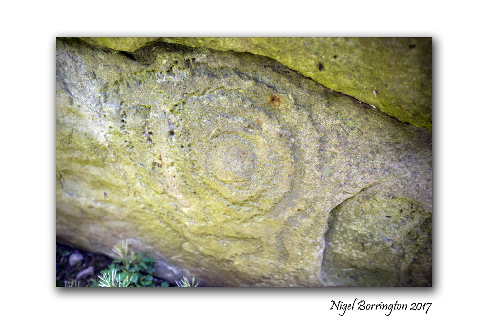
Ireland’s Ancient East , Knockroe Passage Tomb, County Kilkenny

Knockroe Passage Tomb, County Kilkenny
Nigel Borrington
Knockroe Passage Tomb, County Kilkenny
Knockroe Passage tomb is located in a picturesque setting on the slopes above the Lingaun River and old slate quarries which were abandoned in the early 1900’s. The site dates to around 3,000 BC and has many similarities to the far more famous examples such as Newgrange and Knowth in the Brú na Bóinne complex in County Meath.

Originally Knockroe would have been a similar tomb to Newgrange, albeit on a smaller scale. It is likely that it too would have had an earthen mound surrounded by large kerbstones. However unlike Newgrange, Knockroe has two burial chambers, located at the eastern and western sides of the feature. These tombs are exposed, and had long ago lost their earthen cover. Many of the stones lining the passageways of these tombs at Knockroe are highly decorated with megalithic art such as spirals, hollowed ‘cup marks’, and zig-zags. You can still find them in their original locations, and when you see them it is impossible not to wonder about the possible meaning of the decorations – was it purely decorative or did it have a deeper symbolism, and what messages may be in that symbolism? You can also still see the quartz which possibly would have formed a wall around the entrance to the passageways.
Also like Newgrange, Knockroe is aligned with the Winter Solstice. Every year around the 21st December people gather at Knockroe to witness the sun setting in perfect alignment with the length of western tomb.
Knockroe is one of a group of tombs located in this region, all of which are aligned with the large
mound on the summit of Slievenamon in County Tipperary. Knockroe is one of those wonderful sites that you can’t help to keep thinking about long after your visit, without being encumbered with its earthen mound, Knockroe is like the stony skeleton of a Neolithic passage tomb.
Gallery


Loop Head Lighthouse, county Clare, Ireland

Loop Head Lighthouse,
September 2017,
county Clare, Ireland
Nigel Borrington
Loop Head Lighthouse, county Clare, Ireland
I have just spent a few days visiting County Clare, west Ireland, finishing with a visit to the great Loophead lighhouse. As you can see the day was very typical for a Septembers day here in Ireland, wet and windy.
It was still possible to visit the top of the lighthouse however which was great fun in the strong breeze.
I have very much enjoyed visiting some of Ireland’s lighthouses over the years from the north coast down to Hookhead, on the south coast, these remote location with their lighthouse keepers buildings that would have been both a place of work and a home, all year around and in all weather conditions, are a great reminder of the past.
A past that has almost gone but can in places like these still be felt very strongly.
Sometime back I found this video and have shared it before with other lighthouse posts, its still very much worth sharing again however as it reflects on the family life’s of Ireland’s lighthouse keepers …..
Here is a little history of the Loophead lighthouse
History
The first lighthouse on Loophead was one of four known Irish stone vaulted cottage type lights built about 1670. These cottages accommodated the lightkeeper and his family in two or three rooms and had an internal stone stairway between two of the rooms leading up to a platform on the roof where a coal burning brazier or chauffer was positioned. Part of the old cottage with its battered outside wall can still be seen near the lightkeepers’ dwellings.
The light must have fallen into disuse towards the end of the 17th century because it was re-established in 1720 after aldermen and merchants of Limerick petitioned the Irish Parliament in 1717 for a light on the Head.
The cottage-lighthouse with its coal fire was replaced in 1802 by a more conventional lighthouse, built by Thomas Rogers, who was also the contractor. The tower was about the same height as the present tower with four rooms and a lantern. The ground floor room was an oil store and access to the first floor or entrance room by an outside staircase of 19 steps. An internal spiral staircase connected the other two rooms and lantern. The twelve-foot diameter lantern contained twelve oil lamps, each with its own concave parabolic reflector. The reflected light shone through a 22″ diameter convex lens of solid glass, not unlike the ‘bottle glass’ or “bulls-eye” fitted into windows of modern psuedo-Georgian houses.
By 1811 the keeper was living in an adjoining cottage, rather than in the tower.
Loop Head Lighthouse, county Clare, Ireland , Gallery


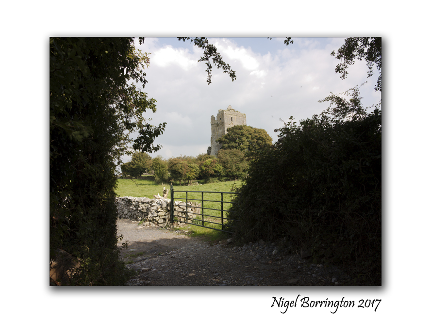
Sense of place : Cullahill Chapel and castle in County Laois, Ireland

Cullahill castle and chapel
County Laois
Ireland
Nigel Borrington
The village of Cullahill, county Laois is located just over the boarder from county Kilkenny. It is home to some great old castle tower home and village chapel remains. Cullahill Castle was the principal stronghold of the MacGillapatricks of Upper Ossory built around 1425 and destroyed around 1650.
There are many places like this in the Irish republic, that have retained the remains of long lost times, this small village located on the R369 just north of Johnstown county kilkenny, is a perfect example of the way most small Irish villages would have been in the 1400’s. this small place is well worth a visit just to get a sense of old Ireland.
Gallery


A sense of place : Allihies and its copper mines
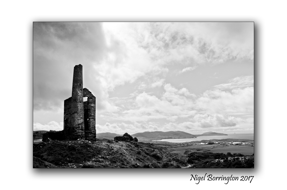
Allihies Copper Mines
Munster
County Cork
Nigel Borrington
One of my favorite locations to visit in Ireland is Allihies in west cork, The village is located towards the end of the Béara Peninsula. Its a very beautiful places to spend sometime walking and visiting the small coves and beaches.
The Village has a long history with Copper mining, started in Allihies in 1812 when John Puxley, a local landlord, identified the large quartz promontory at Dooneen as copper bearing from its bright Malachite staining.
The Allihies Mines
Initial mining began with a tunnel or adit driven into the quartz lode from the pebble beach below. In 1821 two shafts were sunk . Flooding was a continuous problem and in 1823 the engine house was erected to house a steam engine brought over from Cornwall to pump water from the depths. The remains of this building with the base of the chimney can be seen across the road. There is also evidence of a steam powered stamp engine to the left of the chimney and dressing floors in front of the engine house. The high dam further inland is the remaining evidence of a water reservoir which stored the water that was pumped out from the bottom of the mine. It was used for the steam engines and needed to separate the copper from rock. All the rubble on the cliff at the sea side of the road is the crushed useless quartz rock left over after the copper ore was extracted.
This is one of six productive mines in the Allihies area and its operation continued until 1838 when it closed due to failing ore.
John Puxley died in 1860 and in 1868 his son Henry Puxley sold the mines to the new Berehaven Mining Company who reopened the mine and installed a new 22 inch steam engine in 1872. Little ore was produced though in this period and the mine was finally abandoned in 1878.
Time line of Copper Mining at Allihies
Gallery
The following images are taken during my last visit, I hope to return one day soon to this great little historic Irish town.


History in Images, County Kilkenny, Ireland, Kells Priory

Irish History
Kells Priory
County Kilkenny
Nigel Borrington
Kells Priory (Irish: Prióireacht Cheanannais) is one of the largest and most impressive medieval monuments in Ireland.
The Augustine priory at Kells, county Kilkenny is situated alongside King’s River beside the village of Kells, about 15 km south of the medieval city of Kilkenny. The priory is a National Monument and is in the guardianship of the (OPW)Office of Public Works. One of its most striking feature is a collection of medieval tower houses spaced at intervals along and within walls which enclose a site of just over 3 acres (12,000 m2). These give the priory the appearance more of a fortress than of a place of worship and from them comes its local name of “Seven Castles”.
4 km southeast of the priory on the R697 regional road is Kilree round tower and 9th century High Cross, said to be the burial place of Niall Caille Niall mac Áeda (died 917) who was a High King of Ireland.
The Priory has been undergoing a ten year long renovation project that is approaching its completion, the priory is looking amazing and has been secured for many years to come.
Here I post some new images taken during a very enjoyable visit last Sunday afternoon.
A History of Kells Priory
Kells Priory, Gallery


Aghaviller Round Tower and Church

Aghaviller Round Tower and Church
County Kilkenny
Ireland
Nigel Borrington
Aghaviller
Round Tower and Church
Located in county Kilkenny, Aghaviller Round Tower and Church are together one of the most interesting of Irish Historic sites. Based on the presence of the round tower, it is believed that the Agherviller monastic settlement was once a relatively high-status ecclesiastical foundation dating back to Early Christian times. The church and a holy well not far from the site have been dedicated to St Brennain. We don’t know who founded the monastery but it could have been St Brennain. The round tower is built on top of a square stone plinth, an unusual feature which is only found in one other place in Ireland –at nearby Kilree. Sadly, only the lower 9.6 metres of the round tower survived.
The original NE facing round-arched doorway is in its customary location about 4 metres above ground level, although a ground-level lintelled doorway has been added in more recent times. The sandstone tower was unfortunately in deep shade from the nearby dense woods on our late afternoon visit, but it is worth a return trip in morning light to photograph the stonework which is beautifully dressed to the curve inside and out. There is a southwest facing square-headed window at the second storey level.
The church dates to the 12th Century but was significantly modified in the 15th by the addition of a massive tower over the chancel that served as a residence. Only the foundation of the nave remains. An archaeological excavation revealed a gully filled with kiln material and a sizeable ditch/boundary running north–south with stone revetting on its eastern side. This ditch is believed to have surrounded a second or outer enclosure, a common feature of high-status monastic sites.
Gallery


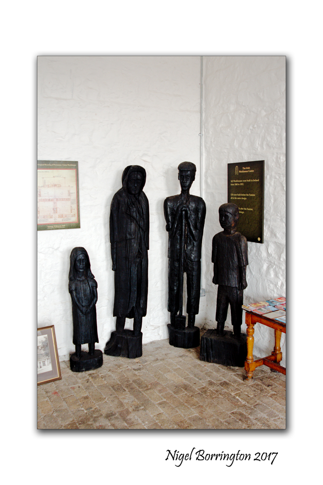
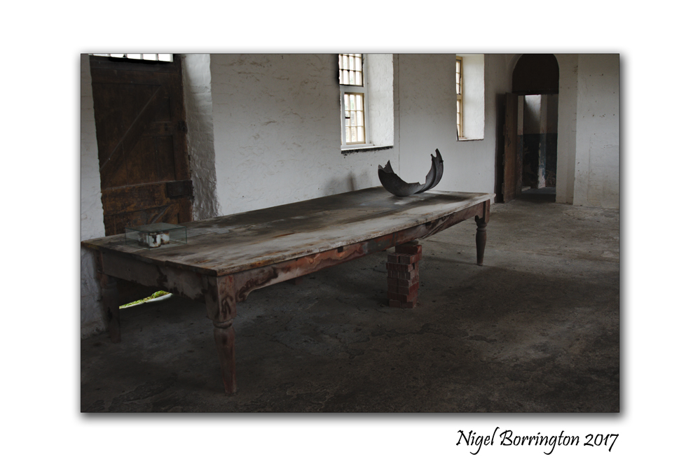
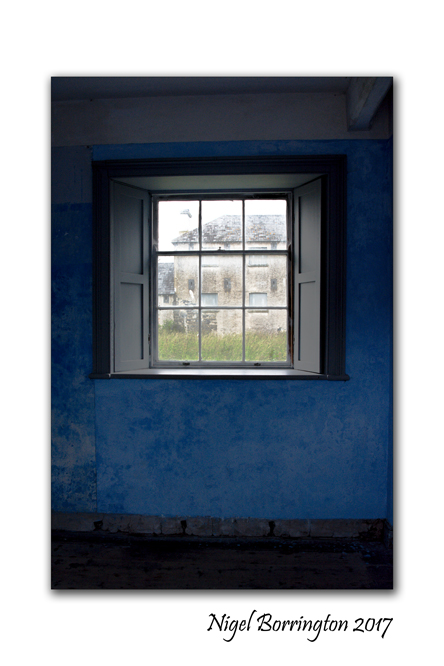
Portumna Work House, The Story of Irish Workhouses

Portumna Work House
Nigel Borrington
The Workhouse Story
The Irish Workhouse – An Overview
What was the workhouse?
The workhouse has been described as “the most feared and hated institution ever established in Ireland.”
The workhouse was an institution which operated in Ireland for a period of some 80 years, from the early 1840s to the early 1920s. There were 163 workhouses in total. If people could not support themselves, they could come into the workhouse. Here they would do some work in return for food. People had to stay and live in the workhouse and so the system was known as indoor relief.
The whole family had to enter together. This was a way for the landlords to clear the land of tenants who could not pay rent. Life in the workhouse was meant to be harsh so as not to encourage people to stay. One of the cruellest aspects of the workhouse was that family members were split up into separate quarters. Children aged two or less could stay with their mothers. Sometimes, family members never saw each other again.
The workhouse was not a prison. People could leave if they liked. The high walls surrounding the workhouses were for keeping out, not for keeping people in.

How did workhouses come about?
In Ireland under Brehon Law, the native laws dating back to Celtic times, rulers had to take care of the sick and the poor. In the 5th Century, Christianity came to Ireland and with it monasteries began to develop. Over time, these monasteries took on the role of caring for the less fortunate. From the mid 1500s, Ireland was invaded by Protestant English settlers. The land was taken from the Irish, the religious were prosecuted and the whole care system broke down.
The situation was so bad that by the beginning of the 1800s, it is estimated that some 2.3 million people were at near starvation level. At the time Ireland’s population was nearing 8 million. By this time also, most of Ireland’s small farmers and landless labourers were dependent on the potato as their main food.
In England, Scotland and Wales there was poverty too. The workhouse was an English system. The first workhouses in England opened in 1836. Almost 700 workhouses were built in England and Wales. The main concern of the Poor Law Commissioners in England was to ensure that the system was not abused by lazy people. Scotland by contrast had a more humane system based on outdoor relief. One of the key differences between England and Ireland at the time was that work was available in England whereas in Ireland, whilst people were willing to work, there was no employment.
In 1800, under the Act of Union, Ireland became part of Britain. Numerous committees were set up to investigate the extreme poverty in Ireland, but nothing was done. However, as more and more Irish people flocked toBritain in search of employment, the British Government acted and sent over one of the English Poor Law Commissioners, George Nicholls, to find a solution. This was his first time i nIreland. He did a quick tour and reported back that Ireland needed a workhouse system similar to the English one. The Irish Poor Law Act became law in 1838.
What did this Poor Law actually mean in practice?
It divided the country into 130 unions. A further 33 were added after the “famine” years. Each union was to have a workhouse and the workhouses were to be financed by a tax on land. George Wilkinson was appointed as architect to the Irish Poor Law Commissioners, to design and supervise the building of the workhouses. The first workhouses opened in 1841.
Before the “famine years”, the number of people entering the workhouses was low. People were slow to leave their holdings. However, by the autumn of 1846, it became clear just how bad the situation was. The potato crop was diseased and inedible. It was emigration, starvation or the workhouse. People began to flood in.
The system, based as it was on indoor relief, could not cope with the overcrowding, the disease and the deaths. Corpses, without coffins, were carried on carts day after day to be thrown into mass burial pits in the workhouse grounds. (The years from 1846 to 1851 are known as the “famine” years. It should be noted however, that while the potato crop was largely wiped out through disease, there were plenty of other foodstuffs such as grain and livestock being exported toEngland.)
After the “famine” years, the numbers of people entering the workhouse decreased and over time it became a place for people that society did not want: unmarried mothers, children born outside of marriage, orphaned and abandoned children, “lunatics and idiots”, old and infirm people, tramps who travelled the roads.
Between 1838 and 1921, the principal features of the poor law and the workhouse system remained largely unchanged. The system was abolished in the early 1920s, when Ireland gained independence from Britain.

What was life in the workhouse like?
Life in the workhouse was harsh and frequently cruel. There were many rules. The food was poor. There was little to do. People were separated from their families, hungry, frustrated, badly treated, bored and mostly without hope. Often the inmates reacted against this, by breaking the rules and by fighting amongst themselves. Some preferred prison to the workhouse as the food was better and the regime not as strict.
Staff were often ex police men or army. There was a very high dismissal rate with many of staff being cruel, incompetent and dishonest.
The diet varied somewhat from workhouse to workhouse. Generally, it consisted of stirabout, which is like porridge, milk and potatoes. Children got bread. Adults received two meals a day and children three. Reports of the time show that the food was often of very poor quality. The workhouse diet remained very basic and it was not until the end of the 1800s that tea, bread for adults and a meat soup dinner were introduced.
Very little productive work was carried out. One of the rules was that the workhouse should not enter into competition with outside businesses. When numbers in the workhouse were large, it was difficult to find work for everybody. In the earlier years, the Capstan wheel was in operation in some workhouses. Women & children, maybe up to several hundred, went around in circles pushing a big wheel for grinding corn. Breaking stones for building roads was a common occupation for the men. The women did domestic jobs such as cleaning or helping in the kitchen or laundry and looking after the sick. Older inmates were put to work mending clothes and spinning wool. Girls were meant to be trained for domestic service. Oakum picking was carried out in many workhouses. This involved separating out the strands of old ship rope so that it could be reused.
There were large numbers of children in the workhouse. In 1850, there were up to 120,000 children. Conditions were terrible for them. An English Clergyman who was in Ireland at the time expressed his shock at the total failure to provide for these children. He described the children in Limerick workhouse as skeletons covered in soars and dressed in rags. Many of the children who survived the “famine” years grew up in the workhouse. They have been described as having “the same guttural voice, a blank expression and of having a strange similarity.” These children only knew the workhouse existence.
Children were supposed to go to school in the workhouse where they were meant to learn reading, writing, arithmetic and the principles of the Christian religion. The reality was quite different. School teachers were often incompetent and cruel, incapable of teaching enormous classes of hungry and dirty children. From the 1860s onwards, social reformers pressed for the boarding out of children to foster families but this was slow to happen, probably because the workhouse would have had to pay the foster families. From about the 1870s onwards, the religious orders began to get involved and started setting up industrial schools, where children were meant to receive training. By the early 1900s, the days of children in the workhouse were beginning to draw to a close.

Did people ever leave the workhouse?
One of the ways that workhouse numbers decreased was through emigration. The cost of emigration to landlords was less than that of keeping paupers in the workhouse. An Emigration Commission was set up. Its representatives visited every workhouse in Ireland. Those who wanted to emigrate were offered free passage, clothing and a little money. Between the years 1848-1850, 4,175 orphan girls aged 14-18 left Irish workhouses forAustralia under a scheme supported by the Australian government. In the 1850s, the Poor Law started to assist young female paupers to Canada where there was demand for domestic servants. Over 15,000 girls were sent there.

Was there anything good about the workhouse system?
Though separate, the workhouse was also paradoxically a part of the locality in which it was situated. It provided business to local suppliers, some employment and medical care to the general population. Originally, the workhouse infirmary or hospital was just for the sick inmates. No qualifications were required for nurses and the level of care was very poor. From the 1860s, qualified nursing sisters began to make their way into the workhouses. Care of the sick improved greatly and the workhouse hospital was opened to non inmates. These local hospitals were missed by many when the system was abolished in the early 1920s. Some of the workhouses became county hospitals or homes. However, for generations that followed, people had an awful fear of spending their final years in the County Home, being as it was part of the workhouse system.
Portumna Work House, A Gallery


The Winter Solstice Live Stream 2017 – Newgrange Ireland
Today I just want to share this You tube link !
For the first time tomorrow morning the website “Ireland ancient east” are sharing the great events that have been taking place at Newgrange for over 5000 year. This is usually a private by invention only event but now the world can share the moment that the sun light travels down the passage tomb opening and falls on the wall at the back of the tomb,
If you can please log on it would be great if as many people as possible can share this Ancient event …..
https://www.irelandsancienteast.com/wintersolstice
Every year, the Winter Solstice at Newgrange, Ireland, attracts crowds to witness the solstice sun illuminate the ancient tomb’s passage and chamber. At dawn, from December 19th to 23rd, a narrow beam of light penetrates the roof-box and reaches the floor of the chamber, gradually extending to the rear of the chamber. As the sun rises higher, the beam widens within the chamber so that the whole room becomes dramatically illuminated. This event lasts for 17 minutes, beginning around 9am.
Share this:
December 20, 2017 | Categories: Comment, Gallery, irish history, Nigel Borrington | Tags: Ireland, Ireland ancient east, irish history, Newgrange, winter solstice, Winter Solstice Live Stream 2017 | 2 Comments