
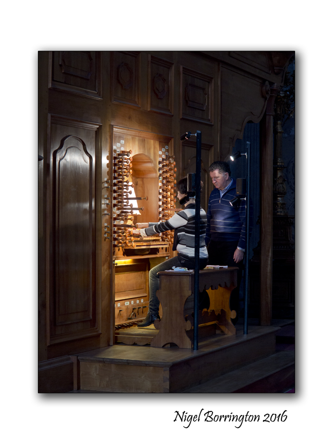
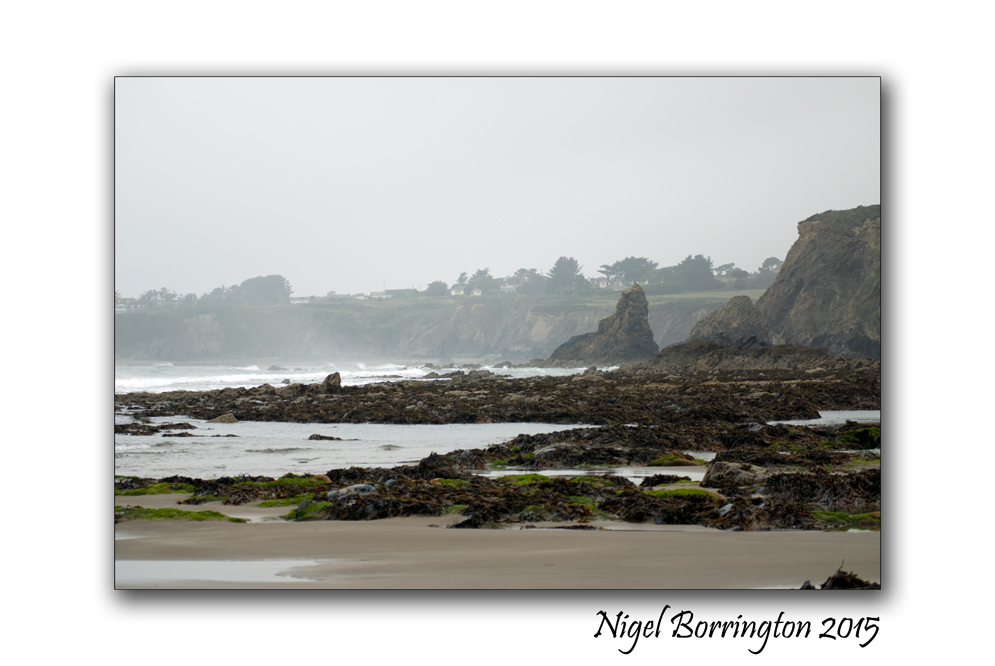
Friday Poetry : The Road

The Road
West Cork, Ireland
Nigel Borrington
The Road
Rockie
Oct 19, 2014
If you were on the road to nowhere,
where would you go?
If you were on the road to somewhere,
would you stay where you are?
If there was no road,
what would you do?
If the road was there,
would you carry on walking?
If the road you walked upon,
was somebody else’s,
would you leave?
If the road you took,
leads to the end of yours,
would you bother turning back?
What would YOU do,
if the feet that led you,
took you onto a road,
that you didn’t know about?
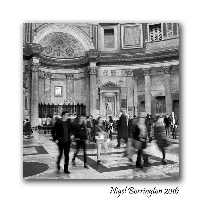
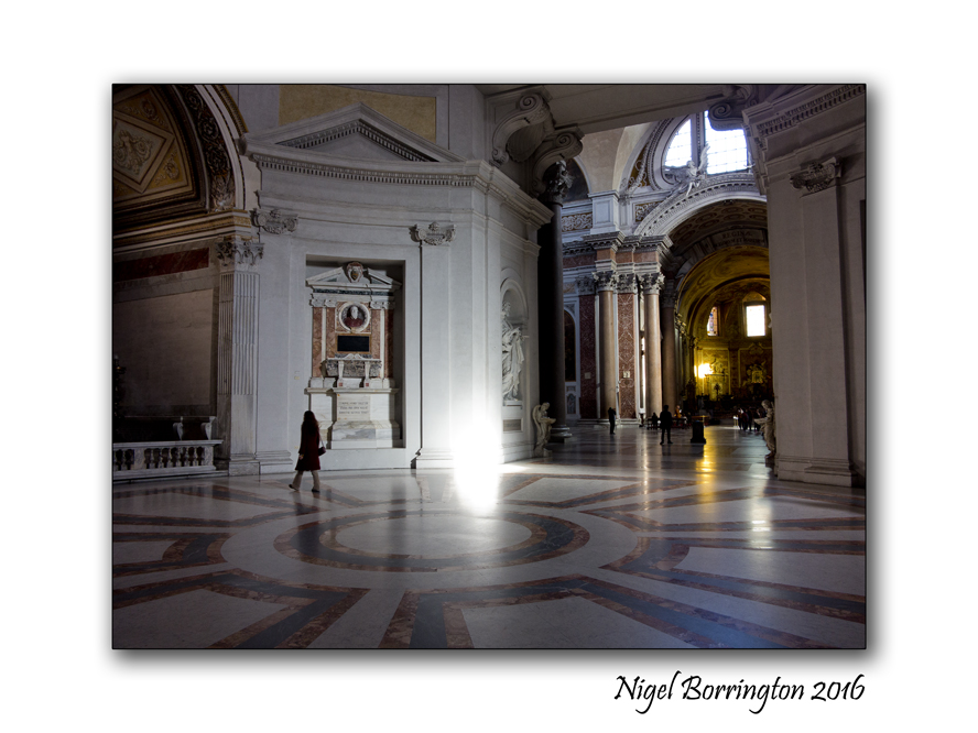
The Pantheon, Rome – in black and white and single words

The Pantheon,
Rome
Photos : Nigel Borrington
A few months back I visited Rome for a few days, I love this great city with its amazing history and people. My favourite place during this trip was the Pantheon, at some point very soon I want to post about this building in more detail, here however I want to strip this post down to the basic feelings I had on walking into this amazing space for the very first time in my life.
I am a big fan of word lists to describe personal experiences, so here goes !
The Pantheon in single words
Hight, awe, time, history, wonder, stone, granite, amazing, structure, art, architecture, human, achievement, skill, maths, space, understanding, power, time, mankind, Greek, Roman, temple, dome, circular, movement, light, time, space, years, moments, minutes, seconds, months, people, tourists, floor, roof, Walls, shapes, colour, openings, doors, markers, movement, sun, light, periods, soul, spirit, gods, existence,art, achievement, understanding, civilisation, Pantheon, Rome, Italy, life, death, memories, people, remembered, empires, lost, evolution, movement, time, love, life, people, seasons, legacy, alive, yesterday, today.
The Pantheon, Rome, a visit in space and time.


The Giants-causeway, Antrim, Ireland
Geology and Myth
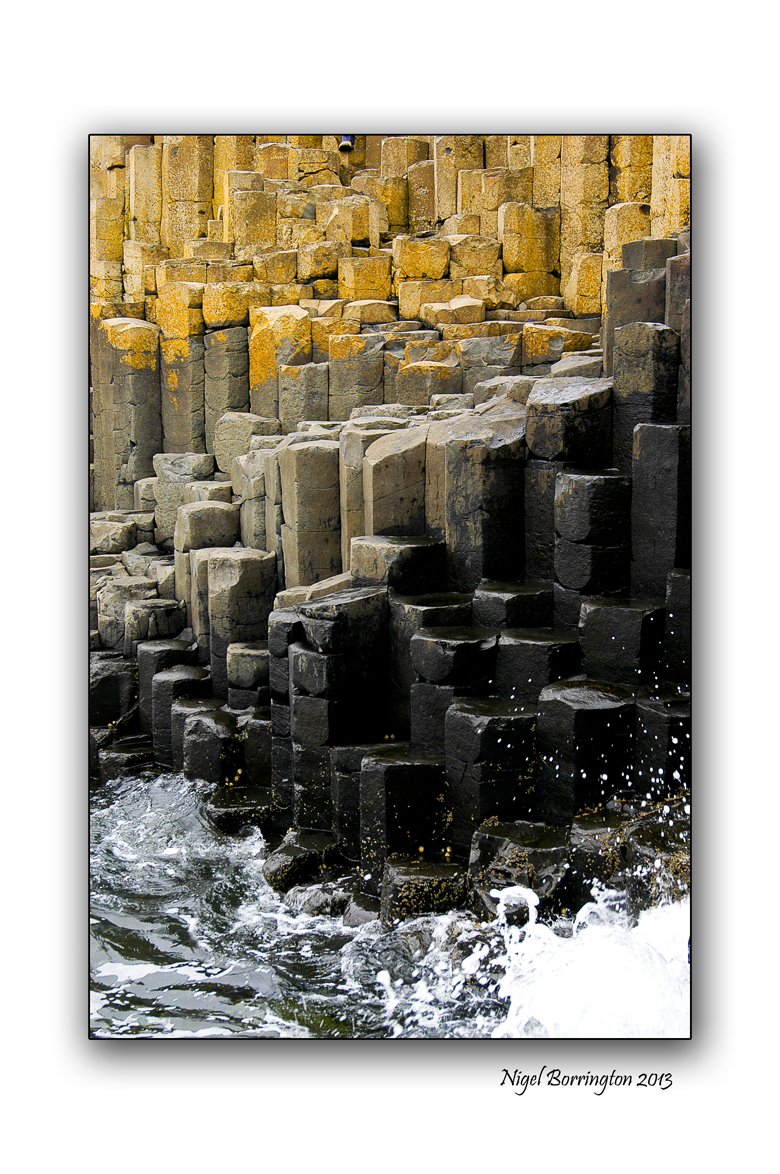
It was on a very wet October morning that we arrived at the giants causeway, its located just outside of the town of Bushmills, county Antrim, on the north Irish coast.
Its a national trust site so you have to pay a fee to get in to the area. Its a small walk from the visitors center to the causeway itself but its well worth it.
This is both a magical and mythical location and one of the worlds most geologically fascinating places.
I took the following images on the day and even though it was very wet and dull I think they get across the feeling you have when your walking around this site. I have added some information as the the geology and the myth’s associated with this truly wonderful place.

The Geology of the causeway
Giant’s Causeway, ( Irish: Clochán an Aifir) promontory of basalt columns along 4 miles (6 km) of the northern coast of Northern Ireland. It lies on the edge of the Antrim plateau between Causeway Head and Benbane Head, some 25 miles (40 km) northeast of Derry. There are approximately 40,000 of these stone pillars, each typically with five to seven irregular sides, jutting out of the cliff faces as if they were steps creeping into the sea.
Formed 50 to 60 million years ago, during the Paleogene Period, the Giant’s Causeway resulted from successive flows of lava inching toward the coast and cooling when they contacted the sea. Layers of basalt formed columns, and the pressure between these columns sculpted them into polygonal shapes that vary from 15 to 20 inches (38 to 51 cm) in diameter and measure up to 82 feet (25 metres) in height. They are arrayed along cliffs averaging some 330 feet (100 metres) in elevation.
Myths behind the magic
Thanks to Kirribilli for this re-telling:
Long, long ago there lived a mighty warrior who was known across the length and breadth of Erin for his strength and bravery, no man on the island was his match and apart from repelling the hoards and the armies that attempted to invade our green land, being the best can be a bit boring and Fionn mac Cumhaill needed a challenge, he needed to prove to himself that he was the greatest warrior both on and off the island.
At that time the scourge of Scotland was a giant called Benandonner and on hearing tales of this beast of a man, Fionn knew that if he could beat this giant, his name would be known the world over. He made his way up to the Ulster coast, shouted across the water at Benandonner and challenged him to a fight.
Now normal people would take a boat and sail across the sea but not these two, they set upon ripping huge rocks out of the ground and throwing them into the sea separating Ireland from Scotland until after hours and days of back-breaking work there stretched a rocky causeway linking the two lands.
They’d agreed to fight between their two lands and seeing that bridge was complete, they made their way across the land bridge. As they approached each other it became apparent how big Benandonner really was, this wasn’t just a big man, this was a true giant.
Now Fionn was not a small man himself but the sheer size of the Scottish giant scared him, suddenly a fight with a monster like that wasn’t as appealing…
So he ran.
But not too far, once he was out of Benandonner’s sight he disguised himself as a baby, which was somewhat apt as he always had his best ideas when he sucked his thumb.
When Benandonner found the baby he asked it who its father was, he was told the baby was Fionn mac Cumhaill’s. When he heard this and saw the size of the baby, he imagined how big the father would be, he would be gigantic, he wouldn’t stand a chance, so he ran.
He ran back to the land of the Scots and on his way back he made sure to destroy the bridge, lest Fionn ever come looking for him…
Gallery


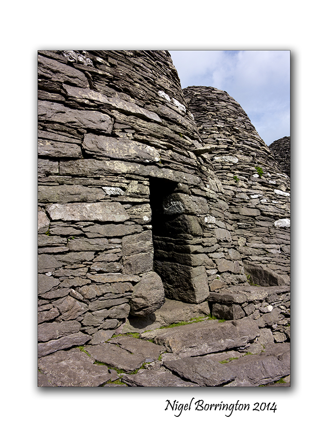
Returning to Skellig Michael, an island escape
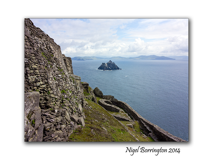
Skellig Michael, county Kerry, Ireland
Landscape Photography : Nigel Borrington
I first visited Skellig Michael in 2012 and the following images and post were taken and created during and following this visit, since then the island has been used during the making of the latest Star Wars movie “The Force Awakens”.
While no one worried too much about this remote and sacred place being used for this purpose, I think a lot of people are very much hoping that it does not mark the start of the island being openly used in such away, here it Ireland places like this are treasured and their peace is defended strongly. The Island is also the home to some very unique and protected wildlife.
Skellig Michael : an island escape
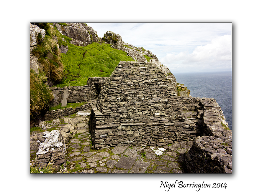
Skellig Michael is an Island some 12 to 16 kilometres by boat from the ring of kerry, county Kerry, Ireland. It is most famous for the fact that during the 6th to the 8th Century’s a religious settlement was established here.
The Island is a world heritage site and falls under the guardianship of UNESCO, you can find the official historic details from the link on the world heritage web page here : Skellig Michael
In my last two posts I shared the boat trip to the Island and then the long but wonderful walk up to the settlement at the very top of the Island some 218 meters from sea level. Today I just want to share images of the inside area , the location that the people who lived here spent their life’s and also the location in which they are buried and there final resting place.
The images in the Gallery below are placed in the order that you view the buildings when you walk through the site, the only access is through a small passage in the outer walls.
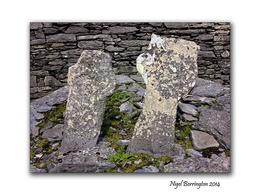
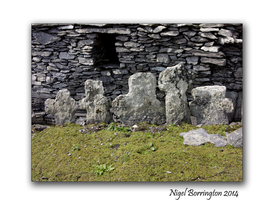
The very first thing that greets you are two small head stones, in a very small patch of grass. These are the graves of two young boys, it was a tradition that monks in this period would take very young boys as members to their orders. These boys where from families on the main land and once they moved here they would most likely never return to see there families. Our guide informed us that it is a possibility that both boys were killed by Viking invaders as when the remains where examined wounds were found that indicate that they were killed by the use of weapons, both boys did not pass the ages of ten or twelve. It is also thought that other graves in the pictures here, in the centre of the living area contain some adult victims of such attacks.
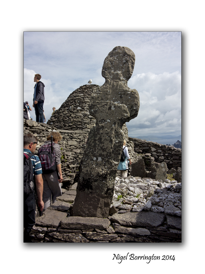
A monastery may have been founded as early as the sixth century, reputedly by Saint Fionán but in 1044 rededicated to Saint Michael, the image here shows a large sculpture that is located towards the middle of the complex. It was described by our guide as being a cross but it could also be very much in the form of a human figure, with the arms to the side and a head looking over the site.
The word Skellig is defined as meaning “splinter of a stone”, and thus this rocky island was dedicated to saint Michael, there are also other Islands around Europe and maybe further away that are dedicated to this saint ( Mont Saint-Michel France, St Michael’s Mount Cornwall)

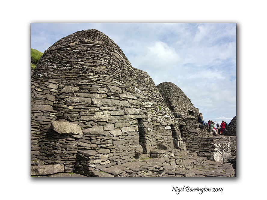
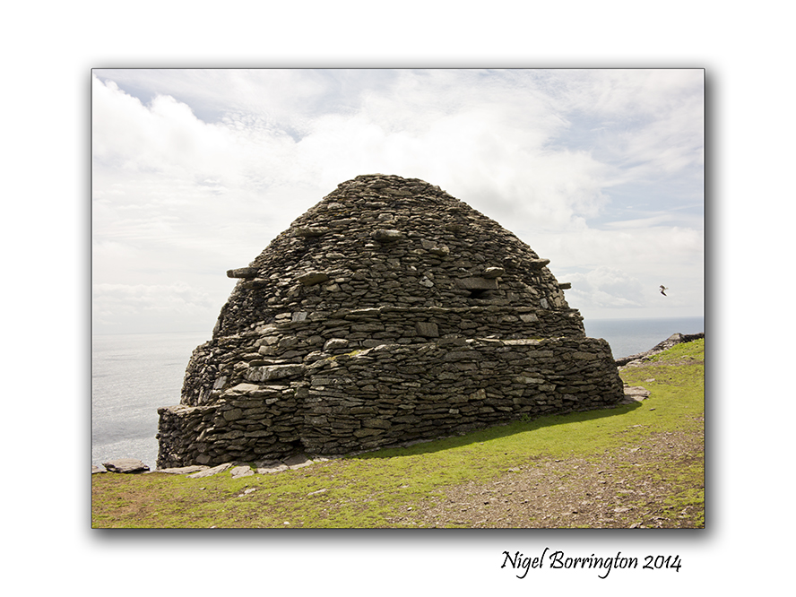
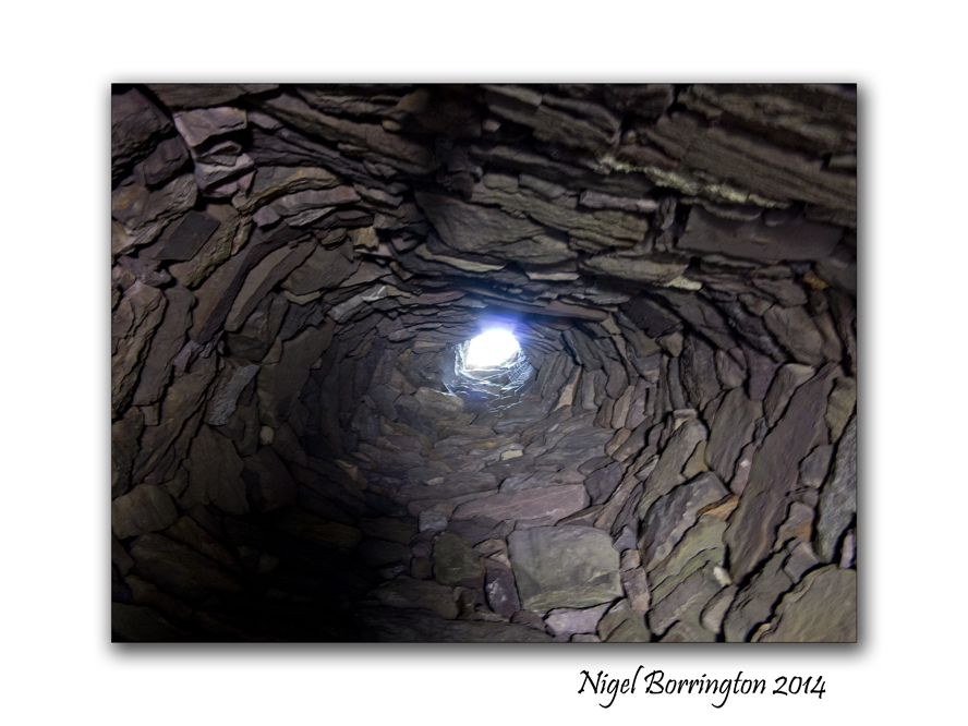
One of the most famous features of Skellig Michael are the so called Beehive structures, there were may be six or seven of these of which six are still standing, they were the living spaces for each of the monks, this fact would indicate that a maximum of seven people lived here in the beehives at any one time, there is a structure at the very end of the settlement that is constructed completely differently, It is thought that the head of the order would have lived in this building but few fact to prove this exist.
In any case the indications are that eight people lived on Skellig Michael at anyone time during its long history.
Living with in these stone constructions looks very harsh , during the time they were occupied however they would have looked very different, in some of the pictures you can see supporting stones that stick out of the main buildings by some amount, it is thought that these stones supported a covering of thatch consisting of straw and clay, this would have been deep and was used to keep the inner stone structure warn and dry. Not all but some of the Beehives have a hole in the roof that was used to let out smoke from fires inside.
At some point I want to post about the life’s of these people, who they where and why they chose to live here, I need to read a little more however , so for the moment that’s it. Three post over the last three day, that I hope share a visit to this wonderful and mystical island.
If you get a chance I would really encourage you to visit. Its an experience of a lifetime and helps you to open your mind to European history.
I cannot help however feeling that this place holds something else other than the official history, The question as to why these monks felt the need to occupy Skellig Michael, so far of the Irish coast line, is very big !
This place feels like an escape, a refuge but from what and why ?
With such massive risk’s taken by a small group of people to construct three stone stair-ways to the top of the Island and then build the walled settlement, the question of why looms very large. These were times when the word of Christianity was first being spread across Ireland so why the need to hide away here ?
I need to do much more reading, before I understand these bigger questions 🙂 and even then maybe some of the answers have been lost !
Gallery


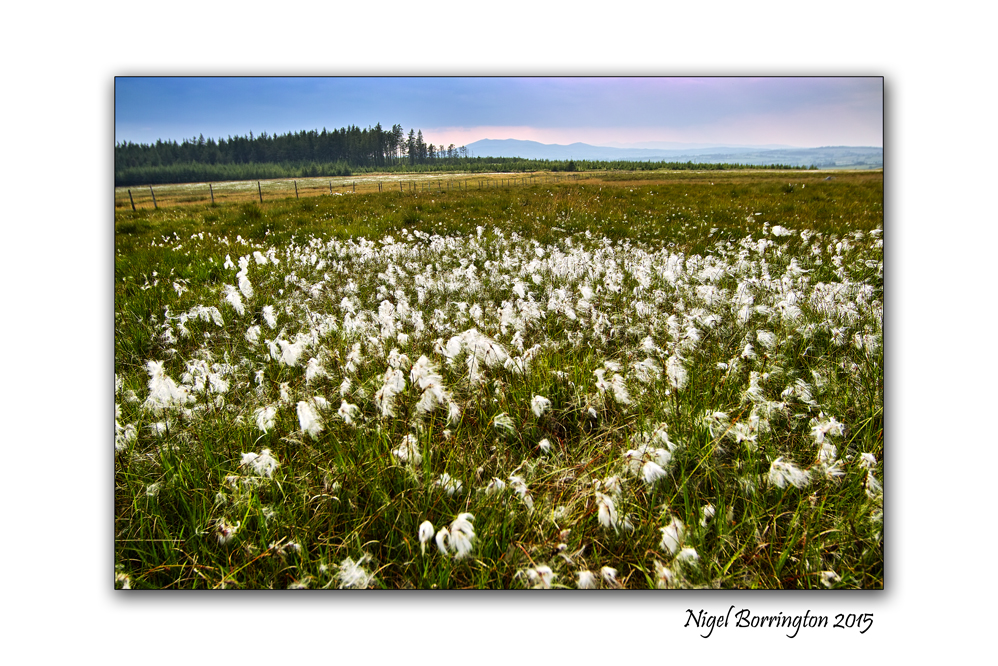
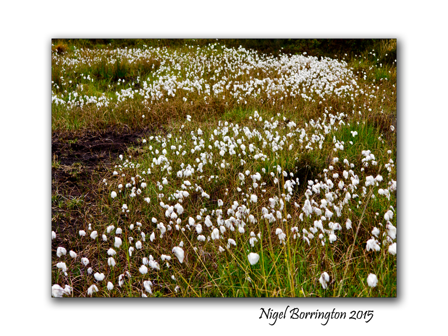
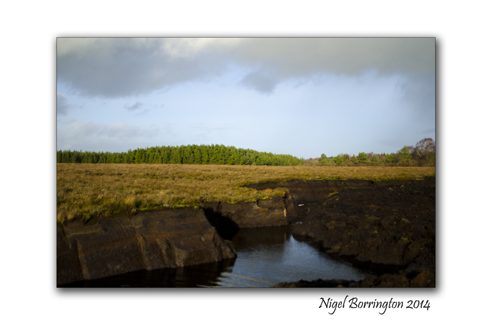
Irish landscape Images for the week – (Monday) Irish bog lands.

During this week, I just wanted to return to some of my most loved Irish Landscape locations and Monday today’s post I want to share some images I have taken since 2014, these relate to the Irish Bog and Peat lands of the Irish Midlands and the West coast.
Ireland has internationally important peat/bog lands but they are always under serious threat. Over the last few years the Irish government has protected areas of special conservation from historic family rights to cut peat in these areas, a decision that created problems for some but one that was very much needed in order to start the process of returning the bog’s to a point of growth and sustainability.
I love these locations, they are remote and full of life both plant and wild life and I feel like many others that they do need very special care and support.
When you visit locations like the Bog of Allen, you can see a contrast between the areas that are still wild and untouched and the areas that have been harvested for peat, when you see this contrast and its different effects on local bio-diversity you would only hope that one day we can find a less damaging way to heat our homes and produce energy.
Irish Bog-lands Gallery


Meerkat’s at Fota Wildlife Park , County Cork, Ireland

A Meerkat at Fota Wildlife Park
County Cork
Ireland
There are so many wild species at Fota Wildlife park, county Cork – but few as sweet and attractive as the little Meerkat’s. Like many of animals they occupy their own island and you view them from across the water of a lake.
I spent a good time during my visit with these little creatures and found it difficult to move on, they are such great fun to watch 🙂 🙂
Here is their introduction and details, provided by Fota wildlife park themselves !
About the Meerkat
A favourite of visitors young and old, the Meerkat is a smaller member of the Mongoose family. Measuring up to 35cm in length and weighing up to 730grams, it has four long, strong claws on each paw to aid with burrowing and likes to stand on its hind legs from high vantage points when possible.
Habitat
The Meerkat is found across southern Africa in the wild, particularly around the savannahs and open plains of Botswana, Namibia, Angola and South Africa.
Wild Notes
The Meerkat is a social and curious animal that lives underground in groups called mobs, gangs or clans. Much of its time is spent digging and foraging for food including insects, roots, eggs, small reptiles and scorpions – the Meerkat is immune to the latter’s poison unlike mankind.
While pack members are feeding, at least one of the mob will be on guard, standing on its back legs and watching for predators such as eagles, foxes for jackals. Should any danger arise, an alarm call will alert the entire group who will then quickly venture underground.
Meerkats share the job of looking after their young. When born, the pups are mostly hairless and cannot see or hear. They generally open their eyes after two weeks and start to eat food other than milk a week later. Females tend to be larger than males and can have as many as four litters of up to five pups a year – generally around rainy season when food is plentiful.
Conservation
Considered to be of Least Concern, local populations of the species are susceptible to disturbances and habitat loss caused by mankind.
Did you know?
The fur on the Meerkat’s belly is thin and helps it to regulate its own body temperature. It sits up or lies on warm ground in order to increase its temperature and reduces it by lying belly-down in a cool, dark burrow.
The Fota Connection
The Park’s Meerkat clan arrived in 2010 and took up residence in a new exhibit near the main entrance. Its habitat has since been revamped further with the addition of a new viewing house, allowing visitors more intimate interaction with one of the world’s most interesting and active species. The original group, Tippy and her three daughters, came from Belfast Zoo but Fota’s numbers have since increased into double figures.
A
The Red Ruffed Lemur from Madagascar, Fota Wildlife Park, County Cork

Red Ruffed Lemur
Fota Wildlife Park
County Cork
Nigel Borrington
There are so many different Species of Wildlife at Corks Fota Wildlife park that you would need many visits in order to get to know as much as you can about them all, along with getting enough time to observer their individual personalities.
During last weekends visit I found so much that I liked about them all but for me the Red Ruffed Lemurs were very special fun to spend some time with. They never stopped moving around their island and their climbing and balancing skills were just amazing to take in.
Here are some basic details about these wonderful Lemur’s
About the Red Ruffed Lemur
Named for the long thick fur that grows around its head and body, the Red Ruffed Lemur is an agile primate that has made the island of Madagascar its home. Males and females look the same – its body is close to its feet, the animal has piercing (sometimes reddish) eyes and it usually weighs between seven and 12 pounds.
Habitat
Ruffed Lemurs are found exclusively on the island of Madagascar off the continent of African, and are generally found in the upper canopy of the tropical rainforests on the eastern side of the island.

Wild Notes
The species is considered to be crepuscular, which simply means that they are most active at dawn and dusk. Their diet consists mainly of fruits, seeds, nectar and plant matter and the animal scent marks its territories and uses an elaborate system of alarm calls to alert other group members if predators are nearby.
Female Red Ruffed Lemurs don’t carry their offspring like most other primates; instead, mothers give birth and leave their young in nests that are generally found between ten and 20 metres above ground level. However, infant mortality is high with about 65% of newborns not reaching three months.
Conservation
The species is listed as being Critically Endangered after a significant decline in population in recent decades because of agriculture, logging and mining activities across its habitat. In fact, over 90% of Madagascar’s original rainforest is gone.
It is estimated that there could be as few as 1,000 to 10,000 left in the wild, while the Black & White Lemur is the most Endangered of the two Ruffed Lemurs.
Did you know?
The Ruffed Lemur feeds on nectar by sticking its long nose deep into the flower. The Lemur’s snout becomes coated with pollen in the process, which is then transported to other flowers – making the animal an important pollinator within its local habitat.
The Fota Connection
The Park is home to three of the 16 species of Lemur and two varieties of the Ruffed Lemur – the Red and Black and White species.
The Ruffed Lemurs are maintained on separate islands alongside each other in the lakes area as they are territorial animals, while Fota has been actively involved in a series of projects aimed at preserving what remains of their natural habitat in Madagascar.
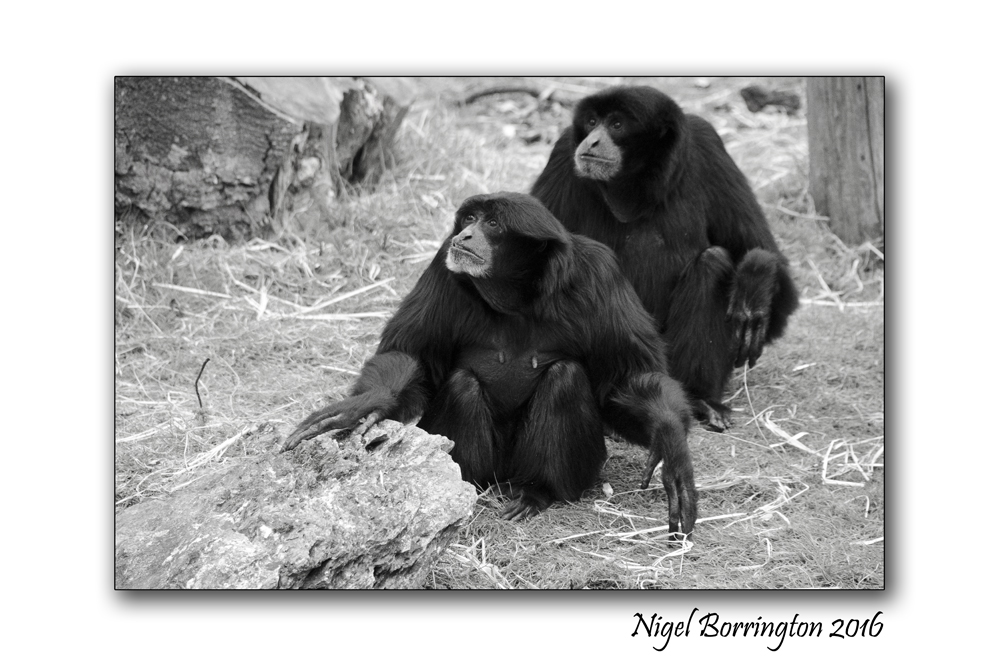
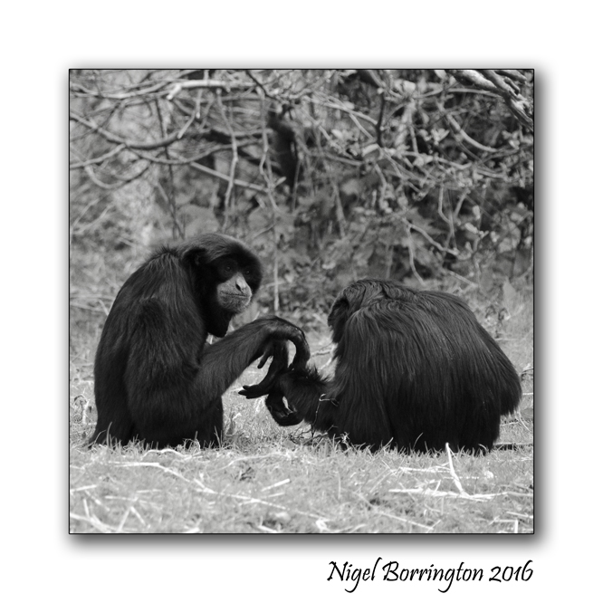
Portraits of Siamang Gibbon’s, Fota Island wildlife park , County Cork
Siamang Gibbon
Fota Wildlife Park
County Cork
Nigel Borrington
During last weekend we visited Fota wildlife park in county cork and spent many great hours getting to know many of the animals they have in their care.
The Siamang Gibbon at the park are all member of the same family 🙂
Here are some details and fact about them , just to help you get to know them a little better 🙂
About the Siamang Gibbon
With a Latin name that means ‘Dweller in the trees’, the Siamang Gibbon is a tailless, black-furred ape that can grow to be twice the size of other Gibbons. Like other apes, the Siamang Gibbon has quite an upright posture and well-developed brain. However, it can weigh up to 14kg and has a special throat sac to amplify its call, which can be heard up to two miles away in the forest canopy.
Habitat
Native to the forests of Sumatra, Malaysia and Thailand, its home range overlaps with both the Lar and Agile Gibbons 0 though because of its largely leaf-eating habits, it does not compete for what the forest has to offer the other species.

Wild Notes
Siamangs are very agile and acrobatic creatures and their extra-long arms help them swing up to 15 feet in one move. Its arms stretch out to help with balance while walking and because it uses its hands so frequently while traveling, the Gibbon tends to carry items with its feet.
Conservation
Siamang Gibbons are considered to be Endangered as 70-80% of their primary habitat has been lost to palm oil production in recent decades. The illegal pet trade has also taken a toll on wild populations, but there are a growing number in existence in captivity across the world.
Did you know?
The Siamang Gibbon mates for life with both parents playing a role in rearing offspring. Breeding males and females also sing duets in order to maintain their bond and establish territory boundaries.
As a fellow ape, the Siamang is also the closest related animal to Mankind in the Park.
The Fota Connection
One of the noisiest crews in the Park, the Siamang Gibbons are hard to ignore and have been at Fota right from the beginning.
They feed on fruit, vegetables, nuts and willow branches and can often engage in long bouts of calling out if the Park is busy and they feel their territory might be under threat. Situated on Monkey Island, their location allows visitors get right up close.
Taking a nap, Bennett’s wallaby (mother and babies) at Fota wildlife park, County Cork

Taking a Nap
Bennetts Wallaby and baby
Nigel Borrington
During the last weekend we visited Fota wildlife park in county cork and spent many great hours getting to know many of the animals they have in their care.
The weather was perfect during the time needed to walk around all the islands and planned routes around the park, with many of the animal on open display and very easy to view you get a very personal experience.
The image above is of a female Bennett’s Walley, with two of her babies resting Snuggly in her pouch, I felt very lucky to get a great view of the three of them as they all napped in the midday sun 🙂

About the Bennett’s Wallaby
Sometimes called the Red-necked Wallaby, the species has a mainly grey coat with reddish shoulders and a black nose and paws. The male’s body can measure up to 90cm in length and weigh up to 18kg; the female, in contrast, is smaller – though both have five clawed-tipped fingers that are used for feeding and grooming.
Habitat
A native of the east coast of Australia and Tasmania, the Bennett’s Wallaby is noctural – resting during the day and coming out to feed at night. Largely a solitary animal, it follows a herbivorous diet and gains most of the water it needs through the food sources it consumes. Breeding can occur at any time of the year with females giving birth to one offspring – known as a Joey – once every 12 months.
Wild Notes
The Wallaby’s ears are very sensitive and are its first line of defence in that it will bound away from a predator as soon as it hears one nearby. Each of its hind legs has an elastic tendon that allows the species catapult itself forward as its tail acts like a rudder, enabling the Wallaby to change direction quickly.

Conservation
Once hunted for their meat and fur and persecuted by ranchers and farmers, Wallabies are now a protected species. The move has seen their numbers in the wild increase in recent years and as the species is tolerant of alternative habitats, it is of Least Concern on the Endangered List.
Did you know?
Similar in size to a grape when born, Joeys grow to 2,000 times its birth weight during the first six months of its life. They begin to leave their mother’s pouch from about seven months and are fully independent at a year old.
The Fota park Connection
The Park’s Wallabies are free ranging and now number between 50 and 70 animals around the island. More easily spotted in the early morning or late evening when the Park is quieter, this species feeds on the grass of the African Savanah or Woodlands areas and tends to be timid and hard to get too close to
——————-
I will post lots more images of all these great creatures at Fota park and do my best to introduce them to you 🙂
Monday in Rome , The Basilica of St. Mary of the Angels

Basilica S Maria Degli Angelie
Rome
Nigel Borrington
A Sense of Place –
The Basilica – Santa Maria degli Angeli e dei Martiri Piazza della Repubblica, in Roma just has to be one of the most beautiful Basilica’s in the city.
Located on the Piazza della Repubblica outside of the Vatican, it is only one of the cities many churches but it holds a level of peace and normality that you cannot find in the likes of St Peters.
Here is just a handful of the many images I enjoyed capturing on a recent visit ….
Gallery


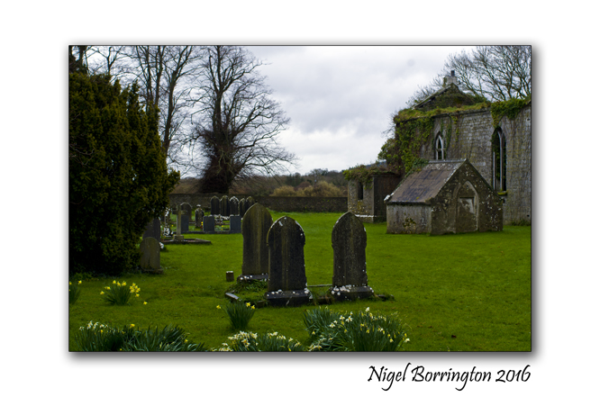
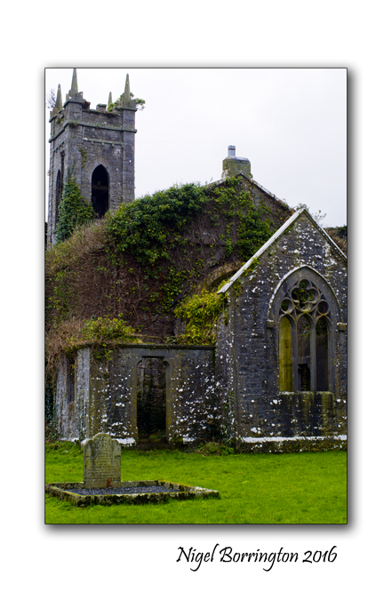
Friday poetry : The To-be-forgotten By Thomas Hardy

It does not take you very long while walking around the Irish Landscape to cross paths with an old abandoned church or two. These old churches are mainly connected to the remains of long evacuated family estates and would have been originally erected as community churches for both the occupants of the estate house and the larger community.
I find these places fascinating for many reasons, a reminder of the past and times of changes around both the 1916 Easter rising and then the Irish Civil War.
I have to be honest I avoid any area of conflict (Political and religious!) in life as much as I possible can, I feel society spends too much time as it is looking back on times of trouble, war and death and wonder sometimes if this is not the very reason why we end up with future conflicts?
For me Life is too short to spend any-time waving flags on behalf of past conflicts – NO ONE WINS IN WAR!
When I come across these old churches however I just have to stop and spend sometime because the names on these grave stones were real people and many of them would have lived full lives and been great family members, loved and been loved, real people!
The To-be-forgotten
By Thomas Hardy
.
I
I heard a small sad sound,
And stood awhile among the tombs around:
“Wherefore, old friends,” said I, “are you distrest,
Now, screened from life’s unrest?”
II
—”O not at being here;
But that our future second death is near;
When, with the living, memory of us numbs,
And blank oblivion comes!
III
“These, our sped ancestry,
Lie here embraced by deeper death than we;
Nor shape nor thought of theirs can you descry
With keenest backward eye.
IV
“They count as quite forgot;
They are as men who have existed not;
Theirs is a loss past loss of fitful breath;
It is the second death.
V
“We here, as yet, each day
Are blest with dear recall; as yet, can say
We hold in some soul loved continuance
Of shape and voice and glance.
VI
“But what has been will be —
First memory, then oblivion’s swallowing sea;
Like men foregone, shall we merge into those
Whose story no one knows.
VII
“For which of us could hope
To show in life that world-awakening scope
Granted the few whose memory none lets die,
But all men magnify?
VIII
“We were but Fortune’s sport;
Things true, things lovely, things of good report
We neither shunned nor sought … We see our bourne,
And seeing it we mourn.”
Ireland’s old churches


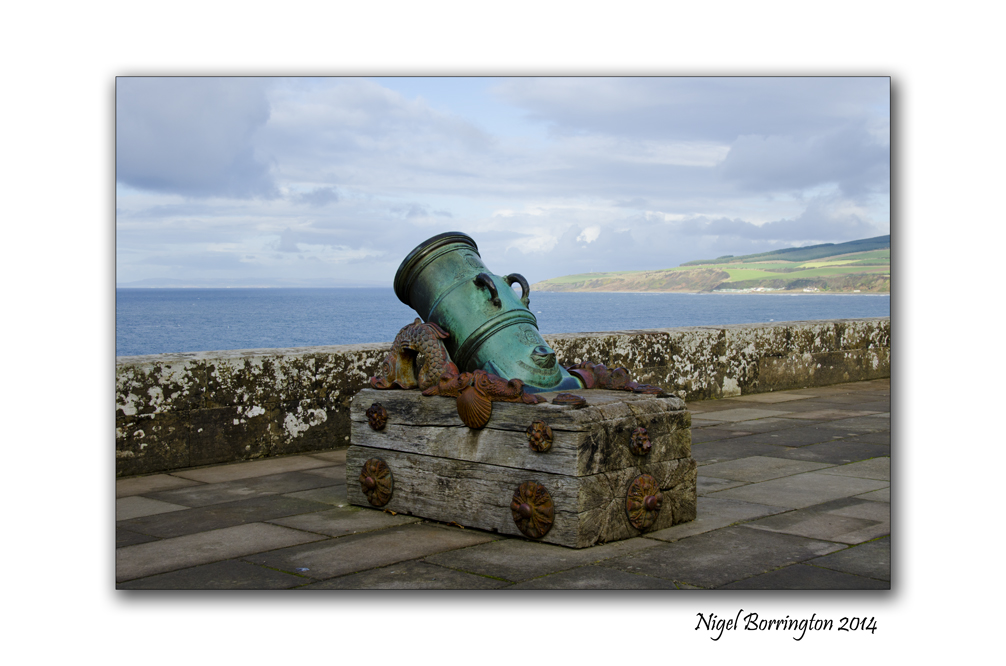
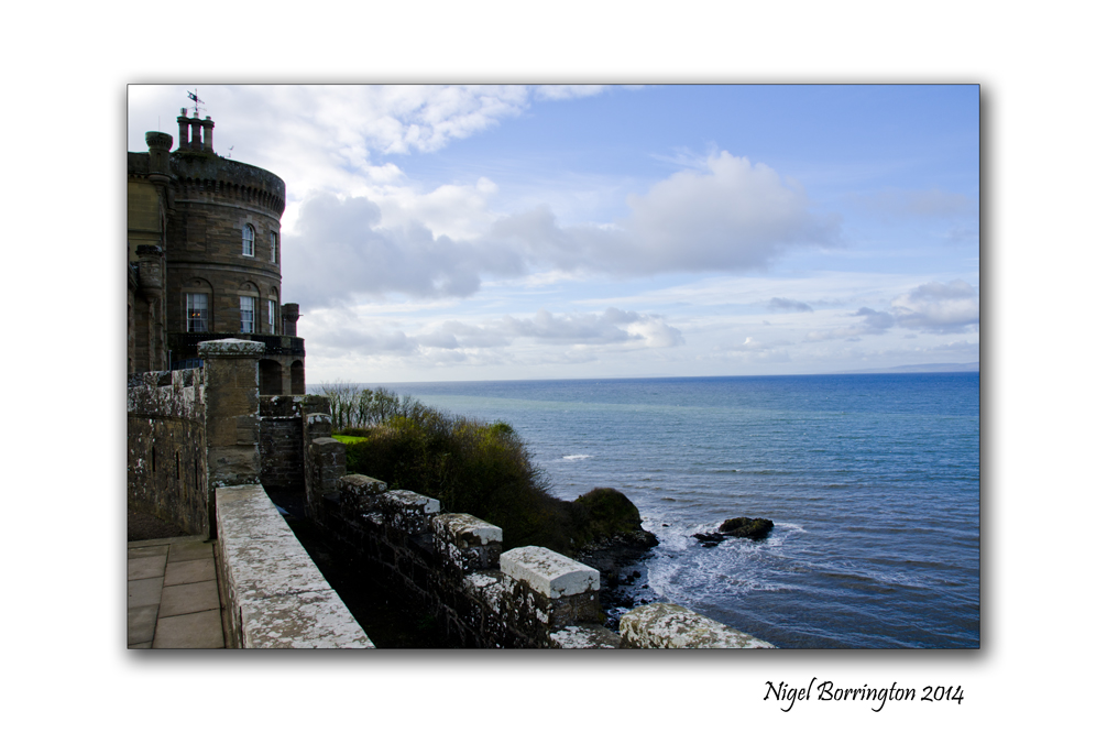
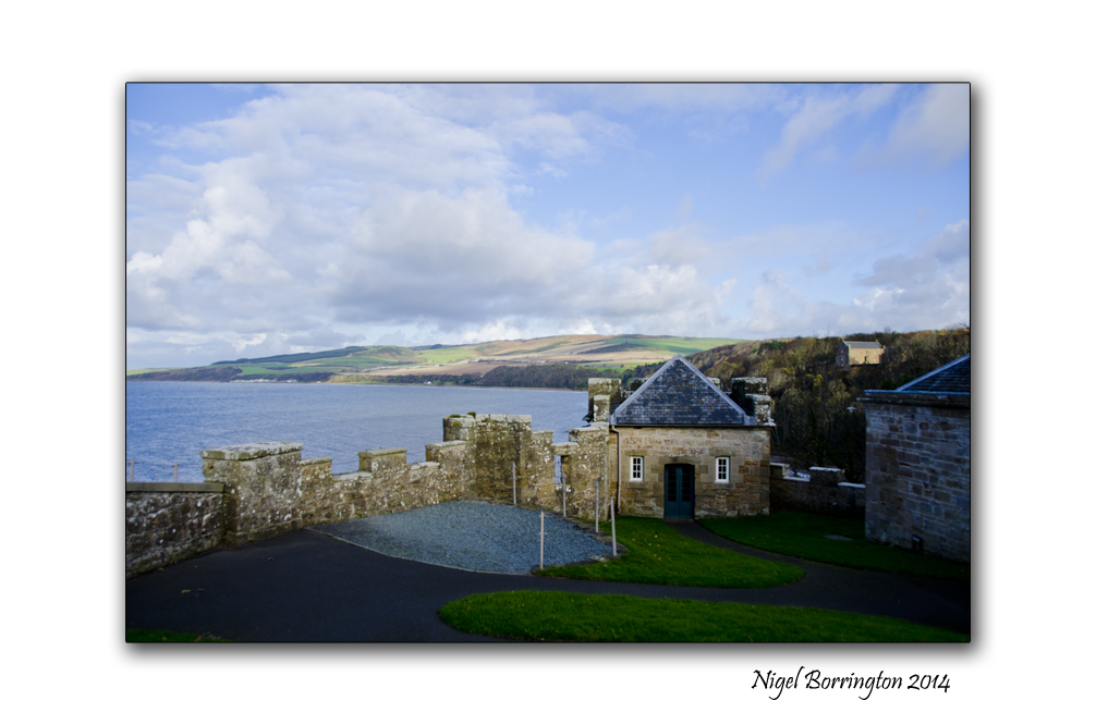
Culzean Castle, Maybole, Carrick, Ayrshire, Scotland

Culzean Castle, Ayrshire, Scotland
Nigel Borrington
It was back in 2014 that I last visited Culzean Castle on the west coast of Scotland, so I am planning another visit as soon as I can, Culzean Castle is in Ayrshire and just has to be one of the most treasured and interesting castles in Scotland.
Robert Adam was the architect and he designed the castles structure on a basic L shaped design. The structure is a fine country house and when completed it was the seat of the 10th of Cassilis ( David Kennedy ) , earldom.
The castle was built in stages between 1777 and 1792. It incorporates a large drum shaped tower, circular inside (which overlooks the sea), a grand oval staircase and a suite of well-appointed apartments.
In 1945, the Kennedy family gave the castle and its grounds to the National Trust for Scotland (thus avoiding inheritance tax). In doing so, they stipulated that the apartment at the top of the castle be given to General of the Army Dwight D. Eisenhower in recognition of his role as Supreme Commander of the Allied Forces in Europe during the Second World War. The General first visited Culzean Castle in 1946 and stayed there four times, including once while President of the United States. An Eisenhower exhibition occupies one of the rooms, with mementoes of his lifetime.
During my own days visit I took many images here as both the grounds and castle itself offer some wonderful photography, including a walked garden, cannon’s, walls, see cliffs and court yards.
If you are visiting Ayrshire , this castle has to be high on your list for a visit.
Culzean Castle , Gallery


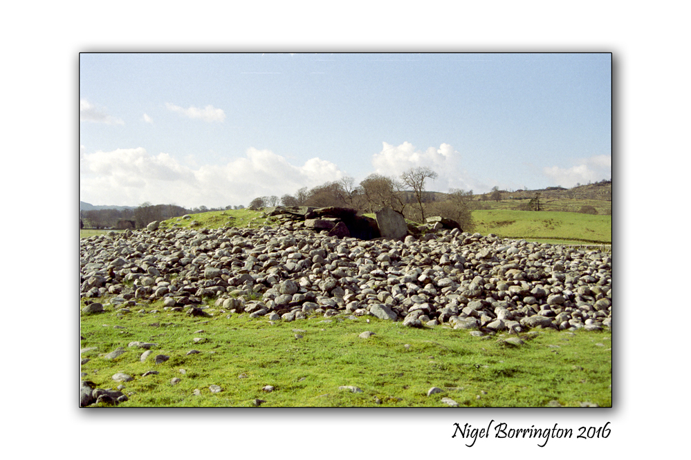
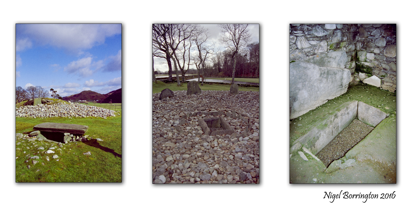
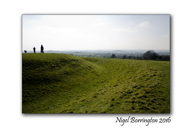
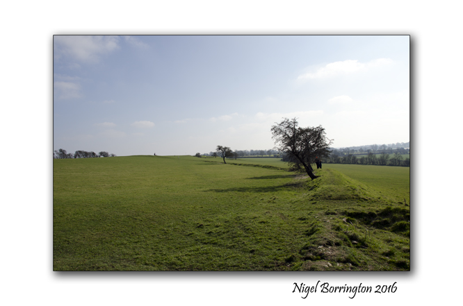
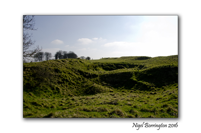
European passage tombs ( Knockroe, county Kilkenny and Kilmartin, Argyll, Scotland )
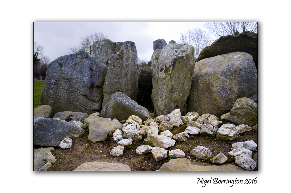
Knockroe, county Kilkenny
Knockroe http://www.megalithicireland.com/Knockroe%20Passage%20Tomb.html
Kilmartin, Argyll, Scotland
Kilmartin http://en.wikipedia.org/wiki/Kilmartin_Glen
A link through time
These two mystical European locations stand two hundred and fifteen miles apart, Knockroe is in county Kilkenny republic of Ireland and the other, Kilmartin is in Argyll, Scotland, about 15 miles south of Oban.

The reason I displaying these images in the same post is simply to highlight something that only occurred to me when one year I happened to visit them only weeks apart. The fact is you could view these two sites individually and study them by themselves all you like, however you would be missing something very important!
The people’s who created these sites shared the same time period and clearly the same beliefs and culture. They lived in Europe both in Ireland and Scotland located in the Geographical British Isles; however some 5500 years ago they knew nothing of recent nations and nationalism , of national borders or even the concept of a European nation.

Both monuments are passage tombs, placed for their dead to be remembered, they both also contain elements for marking the passing of the year and its seasons, by measuring the movement of the sun and the moon.
The structures in these places along with the cultural function they served is identical, to me this shows that these people traveled the seas and not only shared goods and beliefs they in fact where the same peoples. They did not just get on with each other through trade they were each other as brother and sister, mother and father, family and friends.
When they knew nothing of modern boundaries and divisions, what else could they be?
These same people who traveled from one place to another in order to expand their options and abilities did not in any shape or form see themselves as English or Scottish or Irish they were family to each other and nothing more or less!
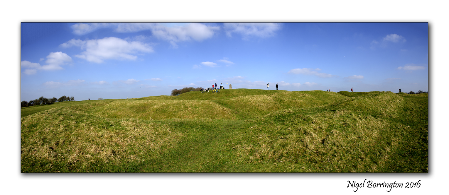
Easter (Ēostre, Ostara ) time on the – Hill of Tara

Easter in Ireland is clearly these days viewed as a religious time in the sense of modern Christianity, however Easter or Ēostre, as a festival has been celebrated for many thousands of years before our current state accepted beliefs….
During last weekend we visited the hill of Tara one of Europe’s and Ireland’s oldest pagan monuments, It was a great time of the year to visit as the air was full of springtime with a feeling that summer was only just around the corner,warm days and long evenings. This is the exact feeling that surrounds the beliefs of the people who made this place so Sacred to their Pagan beliefs in the elements of nature and the seasons. I am never sure if these belief’s can fully be called a religion in modern terms, feeling that they were more a philosophy towards the world that they lived in and cared for very much!
here is a little about the long history of the hill of Tara:
Teamhair is the ancient name given the Hill of Tara. One of the most religious and revered sites in all of Ireland, it was from this hill that the Ard Rí, the High Kings of Ireland, ruled the land. The place was sometimes called Druim Caín (the beautiful ridge) or Druim na Descan (the ridge of the outlook). When walking the path that leads to the top of the hill today, one can easily appreciate why. The long gradual slope eventually flattens at the top for an amazing view of the broad plains in the Boyne and Blackwater valleys below. All that remains of the complex is a series of grass-covered mounds and earthworks that say little about the 5,000 years of habitation this hill has seen.
Most historians, including Biblical scholars, agree that Easter was originally a pagan festival. According to the New Unger’s Bible Dictionary says: “The word Easter is of Saxon origin, Eastra, the goddess of spring, in whose honour sacrifices were offered about Passover time each year. By the eighth century Anglo–Saxons had adopted the name to designate the celebration of Christ’s resurrection.” However, even among those who maintain that Easter has pagan roots, there is some disagreement over which pagan tradition the festival emerged from. Here we will explore some of those perspectives.
Resurrection as a symbol of rebirth
One theory that has been put forward is that the Easter story of crucifixion and resurrection is symbolic of rebirth and renewal and retells the cycle of the seasons, the death and return of the sun.
Hill of Tara Gallery
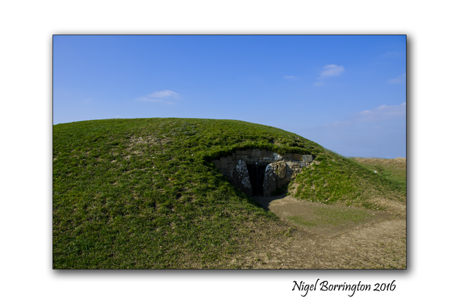


New-grange and the Triple spiral

Boyne Valley, County Meath, Ireland
Nigel Borrington
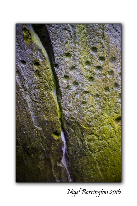
The Tri-Spiral
Is a design engraved on one of the stones inside the middle chamber of Newgrange is probably the most famous Irish Megalithic symbol.
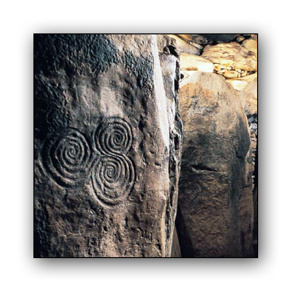
It is often referred to as a Celtic design, but it was carved at least 2500 years before the Celts reached Ireland. At 12 inches in diameter the tri-spiral design is relatively small in size, less than one-third the size of the tri-spiral design on the entrance stone.
Believed by many people to be an ancient symbol of pre-Celtic and Celtic beliefs, the triple spiral appears in various forms in pre-Celtic and Celtic art, with the earliest examples having been carved on pre-Celtic stone monuments, and later examples found in the Celtic Christian illuminated manuscripts of Insular art. The triple spiral was possibly the precursor to the later triskele design found in the manuscripts.
The megalithic tomb of Newgrange in Ireland features several examples of the triple spiral as petroglyphs. These particular examples do not feature three-fold symmetry of later renderings but feature two intertwined spirals with the third originating from the indentation between the other two. This particular feature is rendered with high fidelity in each instance at Newgrange and would suggest a non-tripartite interpretation. One possible interpretation could be the union of male and female (the two entwined spirals) to engender an offspring though how this relates to its setting in a tomb begs explanation.
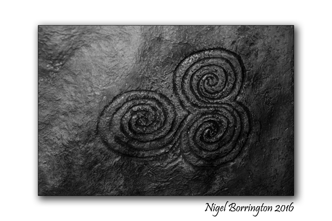
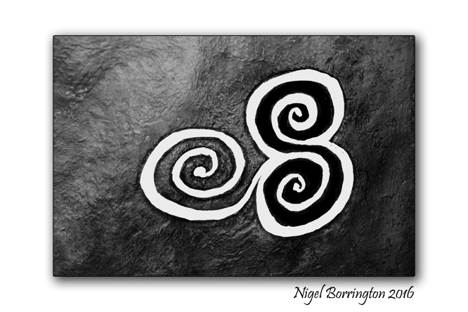
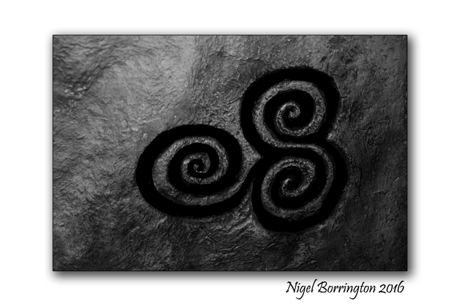
Last night in order to highlight the uniqueness of the Newgrange spirals, I produced the following versions by tracing over a photograph I took of the original, thus producing different drawings using both the positive an negative spaces of the relief.
You can read into these your own interpretation of the original meaning ….

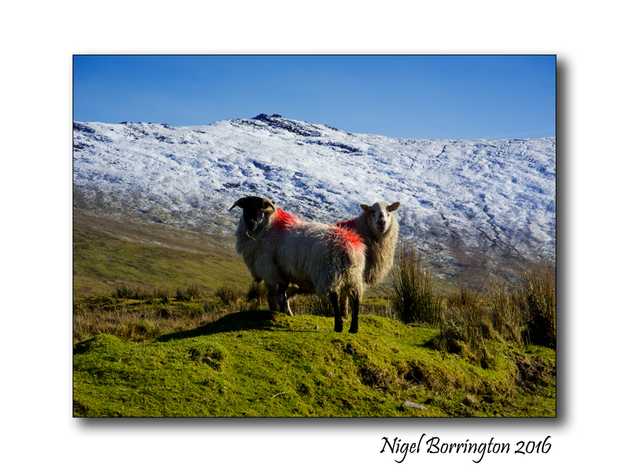
St Patrick’s day a Landscape Gallery 2016

The Mountain of Slievenamon
County Tipperary
Ireland
Nigel Borrington
Happy St Patrick’s day everyone !!!!!
For the last few St Patrick’s day Holidays, I have posted some of my Landscape images from around Ireland , today I want to do the same as I feel that for me today is about celebrating the great landscape’s Ireland has to offer and getting outside to enjoy the real Ireland that surrounds the people who have made it their home.
Ireland: a St, Patrick’s Landscape Gallery


A sense of place, Wellington Tower Grange Crag, County Tipperary

The Wellington Tower Grange Crag, County Tipperary
The Wellington Tower stands on the Crag above Grange, county Tipperary, it was built in 1817 by Sir William Barker Bar to celebrate the Duke of Wellington’s victory over the French at the battle of Waterloo. Today it is nearly two hundred years old and for a long time it has only formed a feature in the loop wall around the forest above the small village of Grange.
However over the last months it has been restored and transformed into a viewing platform as you can see from the images here, it has been amazing to see the work that has been performed to give the tower a new life and a new purpose in life.
The walk to the top of the tower is via a metal spiral staircase with a viewing platform at the top , if you are a little heady with heights its best not to look down through the steps and to just keep going until you get to the top.
Once you are on the platform above and walk to the chest-high wall in front of you the view of county Tipperary below is just amazing. There is a display of all the sights below on a board the looks out and to the distance you can see modern Ireland in it greatness form with its small towns and up to date Wind farms.
Wellington Tower , Grange Crag, Tipperary GALLEY …


Irish Landscape photography, a few miles from home
The Mountain of Slievenamon
County Tipperary
Ireland
Nigel Borrington
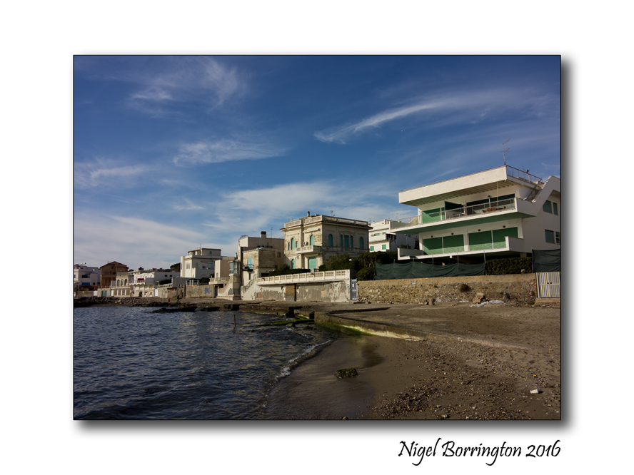
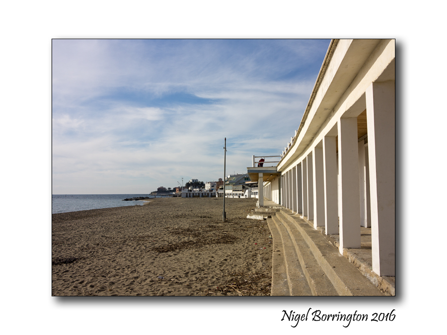
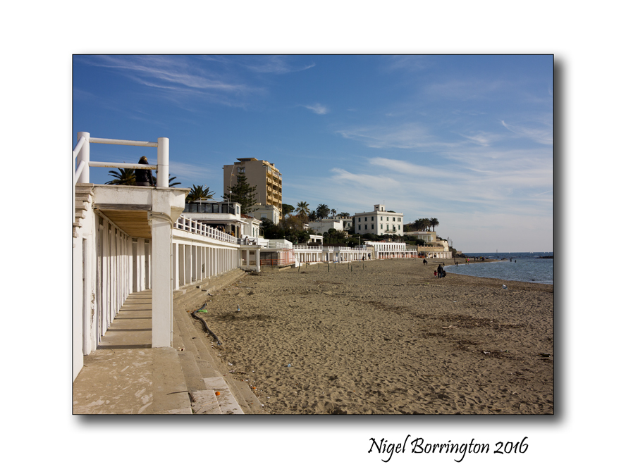
The Train to Santa Marinella
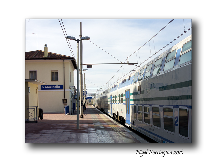
On a recent holiday to Italy we took a train from Rome to the coastal town of Santa Marinella. From Termini station in Rome this is about a 45min trip through the country north west of the capital city.
The train Station at Santa Marinella is located in the side streets of the town but you only have to walk out of the station and turn right and you are looking down the street towards the beach.
As you can see from the pictures I took around the beach area it’s is a very well kept town and beaches, this was a winters day in December 2015 so there was very few people around however because its close to Rome I can imaging in the summer it would be much busier.
If you are in Rome for a Holiday and want to get out of the city for a while then this is a great place to visit, for lunch and coffee with a view of a sea front.

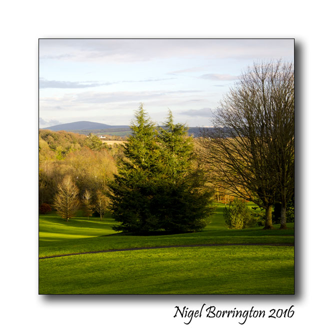
Irish Landscapes – Mount Juliet Estate, Co.Kilkenny
Irish Landscapes
Mount Juliet Estate
county Kilkenny
Nigel Borrington
Mount Juliet was built in 1757 by the Earl of Carrick in compliment to his wife, Lady Juliana (Juliet). This estate has very strong Norman associations and in particular with the great Butler family.

The estate was originally two separate estates called Walton’s Grove and Ballylinch. The Waltons were the owners until 1653 when they were dispossessed by Oliver Cromwell. It later fell into the hands of King James II. It was then sold to a Mr Sweet, followed by a Mr Kendal who changed it’s name to ‘Kendal’s Grove’ in 1719. Mr Kendal left the entire property to the local Rev. Bushe who retrieved an important portfolio for him after being ‘mugged’ by a highway!
Rev. Bushe was wildly extravagant, ran up enormous debts and eventually sold the estate to his neighbour, the Earl of Carrick. It remained in this family from the 1750s until 1914, when the present Earl sold the estate to the McCalmont family who lived here until quite recently.

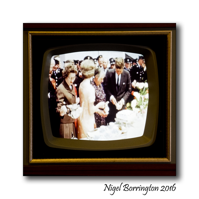
When President Kennedy visited Ireland in 1963 – Kennedy Homestead, Co.Wexford

Kennedy Homestead
Co, Wexford
Nigel Borrington
This very modest and humble farm yard and surrounding buildings, Located at ( Dunganstown, New Ross, Co. Wexford, Ireland ) is the birthplace of President John F. Kennedy’s great-grandfather Patrick Kennedy.
So it was that back in June 1963, the President of the USA decided that it was high time to take a visit to his grandfathers home. The Presidents visit to Ireland included these very key moments, in the visit to the family Homestead, drinking a cup of tea and enjoying some sandwiches with his Irish cousins.
In the years that followed his visit the family home has been turned into an equally modest but great exhibition centre, with a new building that contains many great photos and films relating to JFK and his family history.
It is hard to escape the ironic fact that while this was a very successful attempt to catch up with his own family and its history, by taking a few moments here – that he himself described as “The best moments of his life”, the visit took place only weeks before his own death in Dallas on the 22nd of November 1963.
His parting words to his Irish cousins, related to the fact that he understood very well that they may have found it very disruptive, the worlds media arriving in their small farm yard, so while he made a promised to revisit, he also promised that it would only be every ten years or so, clearly however this was to be his first and very last visit with them ……
Gallery


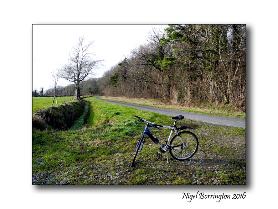
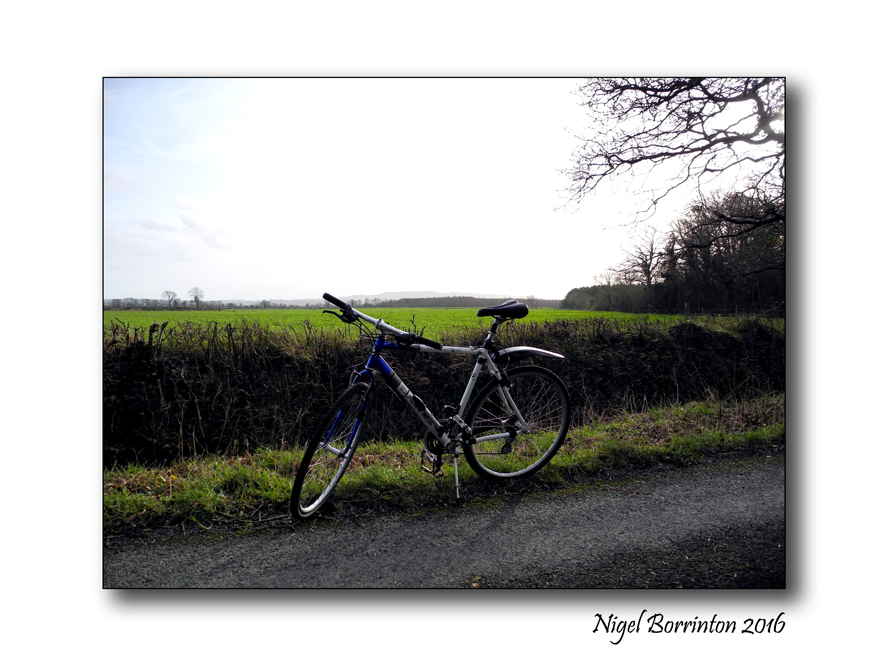
County Kilkenny, Landscapes images from a cycle
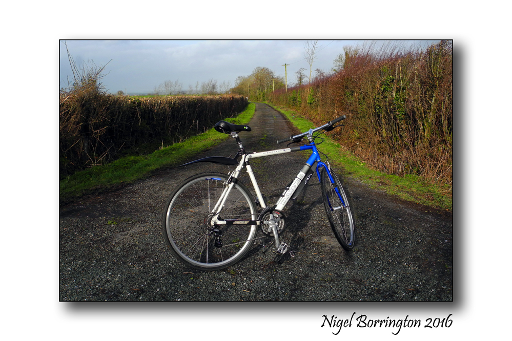
Cycling Kilkenny
As the new year began in full, I made the decision to get my cycle back on the road for 2016, I have owned this bike for about 18 years and during that time made some great use of it. Over the last few years however I had been using it less and less, so I guess its time to start some new adventures on it.
I finished getting everything back to a good condition, with a service about two weeks ago and have been taking local trips as often as possible during January.
I feel already that it is great to be out on the open road and its good to be able to just stop where you like and take out the camera to get some images, no need for finding a place to park up and you can stop the moment you see something, anything, you want a picture of.


Images of Ireland, The Connemara Mountains Galway
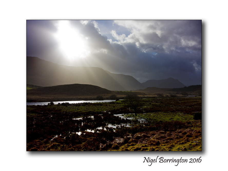
Connemara mountains
Irish Landscapes
Nigel Borrington
At the end of last week I visited the Connemara Mountains in County Galway, one of Ireland most beautiful landscape areas.
The weather was just amazing, changing every ten minutes with heavy showers moving very quickly across the mountains and lakes.
I just love this part of Ireland, the mountains here contain the following ranges ….
Mountains in County Galway
Twelve Bens
The Twelve Bens or Twelve Pins (Irish Na Beanna Beola) is a mountain range in Connemara. Dedicated hill climbers can hike all twelve in a single day. The twelve Bens are a group of small mountains that are the dominant feature of the Connemara countryside. They are easily accessible from the N59 or from the villages of Letterfrack or Recess.
Mweelrea Mountains
Mweelrea rising from the northern shores of Killary Harbour, is one of the finest mountain massifs in Ireland. It may be climbed from Delphi following the ridges to the fjord.
Maamturk Mountains
Mammturk Mountains are a picturesque mountain range in North Connemara. They are less well known than their more famous neighbours, the Twelve Bens on the other side of the Inagh Valley. They are not very big (max 667m) but a pleasant climb in fine weather, with superb views and no congestion.
Mount Gable
Mount Gable (1370 feet) is one of the most beautiful and scenic mountain walks in Ireland. It dominates the isthmus between Lough Corrib and Lough Mask and guards one of the major routes into Connemara from the east. The starting point for a walk is approximately 2km from the village of Clonbur.
Slieve Aughty Mountains
The Slieve Aughty Mountains are a mountain range spread over both County Galway and County Clare. The highest peak in the Slieve Aughty Mountains is Maghera in Clare which rises to 400m (1,314ft). The mountain range consists of two ridges divided by the Owendallaigh river which flows west into Lough Cutra.

Irish Lighthouses – St John’s Point Lighthouse, Donegal
I have been spending a little time each evening this week sorting through by Landscape images of Ireland, it’s been a great exercise to do and has reminded be of so many of the great locations I have visited here in this great country.
I have always keep a special place in my mind and memories for the many Lighthouses I have been to visit, from the south coast to the very north of the country, like The lighthouse below, which I posted about sometime back 🙂
St John’s Point Lighthouse, Donegal
Last week I changed my blog header to an image of St, Johns Point Lighthouse in county Donegal, so I though I would just share some details about this great place.
Its an amazing lighthouse at the mouth of Donegal bay and like many Lighthouses it was build through hard work and taking a risk with time and money, followed with many years of hard work and care in order to keep it running so that many lives could be saved.
Some History
From the Commissioners of Irish Lights
This is a harbour light used to guide from Donegal Bay, it marks the north side of the bay leading to Killybegs Harbour from the entrance up to Rotten Island.
The Corporation for Preserving and Improving the Port of Dublin (the Ballast Board) received a request on 24 February 1825 signed by merchants and traders of Killybegs requesting a light on St John’s Point. This was not approved until April 1829, and Trinity House gave their statutory sanction the following month.
The tower, built of cut granite, was designed by the Board’s Inspector of Works and Inspector of Lighthouses, George Halpin, and erected by the Board’s workmen under Halpin’s supervision.
The tower, painted white, had a first order catoptric fixed light 98 feet above high water with a visibility in clear weather of 14 miles. The light was first used on 4 November 1831 with the buildings in an uncompleted state. The final cost at the end of 1833 was £10,507.8.5.
Gallery
A Lighthouse Poem
By : Ashley Rose
The stone facade bound into the coarse rock,
Signaling, sending, and saving,
Streaks of light alluring threat to vessels.
Like flare of alert, warning of an ominous havoc.
Sending waves of whispering light into the mute air,
Advising all to depart back to the watchful sea.
The light reflects on the storm driven oceans,
tracing the surface with an inkling of caution,
a lighthouse, beacon of hope.
The tides swoosh against the jagged cliff,
where tattered remains of a ship remain.
The waves roar as a dull overcast envelopes the sky.
The lighthouse’s beams echo off a ship,
leading the wandering adrift to safer waters,
as a guide to shelter.
Share this:
April 28, 2016 | Categories: Comment, Gallery, Landscape, Nigel Borrington, Poetry Gallery, Travel Locations | Tags: Ashley Rose, County Donegal Irish Landscape, Donegal, Irish photography, Lighthouses, Nigel Borrington, poem, poetry, St johns point | 3 Comments